Posts

Banner of the AGU Annual Meeting 2023 taking place in San Francisco from the 11th to the 15th of December 2023.

The ESA Altimetry Virtual Lab on EarthConsole® at the AGU Annual Meeting 2023

The ESA Altimetry Virtual Lab hosted on EarthConsole® is set to take center stage at the AGU Annual Meeting 2023, offering a unique opportunity for attendees to delve into the world of its altimetry data processing services.

Dr. Jérôme Benveniste, the Lab’s initiator and Senior Advisor at the European Space Agency (ESA), is geared up to personally walk you through the online and on-demand services that make up the Lab’s portfolio during a dedicated poster session.

So if you will be in San Francisco for AGU 2023, mark your calendar for Thursday, 14 December 2023, from 14:10 to 18:30 PST, and head to Poster Hall A-C – South (Exhibition Level, South, MC) to discover:

  • The ESA-ESRIN SARvatore service for CS-2 and S-3 services, which allow users to customize the processing at L1b & L2 (a list of configurable options for, e.g., SAMOSA+/++ and ALES+ SAR retrackers, not yet available in the ESA Ground Segment).
  • The ESA SAMPY (Cryo-TEMPO project) for CryoSat-2 to append the SAMOSA+ retracker output to official CryoSat-2 Level-2 GOP products.
  • The TUDaBo SAR-RDSAR (TU Darmstadt–U Bonn SAR-Reduced SAR) for CS-2 and S-3. It allows users to generate reduced SAR, unfocused SAR & LRMC data, with configurable L1b & L2 processing options and retrackers (BMLE3, SINC2, TALES, SINCS, SINCS OV).
  • The TU München ALES+ SAR for CS-2 and S-3. It allows users to process official L1b data and produces L2 products by applying the empirical ALES+ SAR subwaveform retracker, including a dedicated Sea State Bias solution.
  • The Aresys Fully-Focused SAR for CS-2 & S-3, to produce L1b products with configurable options and appending the ALES+ FFSAR output.

And here’s the best part – if you’re not part of the Lab’s 100+users community, you can join for free.

We look forward to welcoming you to the ESA Altimetry Virtual Lab!

EarthConsole® Stories: ESA Arctic+ Salinity project studying freshwater fluxes in the Arctic

EarthConsole® Stories are experiences about how we helped universities, research centres or service developers to leverage earth observation data to extract valuable insights for their research, educational or pre-commercial projects.

The Project

Sea salinity is a key parameter that controls the ocean circulation, and currents are key drivers of the climate of the planet.

Sea Surface Salinity (SSS) serves as a crucial indicator for tracking currents and also freshwater content and fluxes as water with low salt levels can be a sign of freshwater sources like rivers and streams that flow into the ocean. This is especially important in the Arctic region, where significant changes are occurring.

However, it’s important to note that there aren’t many salinity in-situ measurements available in the Arctic region. Due to this scarcity, the use of remote sensing technology to measure salinity, specifically through L-band radiometry satellites like SMOS (Soil Moisture and Ocean Salinity) and SMAP (Soil Moisture Active Passive), becomes particularly important in this area.

In the Arctic region, accurately measuring Sea Surface Salinity (SSS) is difficult for a couple of reasons. First because the satellites used (L-band satellites) are not as sensitive to changes in salinity in cold waters. Secondly the presence of sea ice complicates matters further as it interferes with satellites readings and requires careful processing.

The ESA Arctic+ Salinity project aims to address these issues and contribute significantly to bridging the knowledge gap regarding changes in freshwater fluxes in the Arctic region.

The Need

As part of the project, the research team needed to develop a new regional Arctic SMOS SSS product with the goal of enhancing two fundamental components for calculating freshwater content in the Arctic:

  • Effective spatial resolution: to enhance the clarity of satellite measurements by reducing possible disturbances in the data collected by the satellites;
  • Better characterization of the sea surface salinity dynamics: to mitigate the different errors affecting the SMOS measurements taken at different points in time.

To achieve this objective, the team decided to resort to the G-BOX hosting environment service available at EarthConsole®.

The project impact

This project will greatly help the research community. Scientists will get accurate up-to-date maps of salinity dynamics, using data from SMOS and a combination of SMOS and SMAP satellites.

This project has been supported via the ESA Network of Resources initiative.

Banner including a picture of swell waves

EarthConsole® Stories: Sentinel-6 potential of swell wave detection using FF-SAR data

EarthConsole® Stories are experiences about how we helped universities, research centres or service developers to leverage earth observation data to extract valuable insights for their research, educational or pre-commercial projects.

The Project

In the context of the Space Flight MSc program at the faculty of Aerospace Engineering of the Delft University of Technology, this thesis project delved into the capabilities of the Sentinel-6 Michael Freilich satellite, the latest satellite altimetry mission, launched in November 2020 as part of the Copernicus programme.

The project aimed to compare two types of data, Level 1b Sentinel-6 Fully Focused Synthetic Aperture Radar (SAR) RAW and RMC data, to evaluate their differences in monitoring swell waves.

The project focused on the Channel Islands of California, where the presence of swells is dominant and especially evident in the winter period.

The Need

Recent research has shown that the performance of the RMC mode in unfocused SAR meets expectations. However, when it comes to fully focused SAR applications, there was still a need to evaluate the differences with RAW data.

That’s where EarthConsole® came into play. EarthConsole®’s Altimetry Virtual Lab provides the FF-SAR processor for Sentinel-6 developed by Aresys. This processor handles the entire journey of Sentinel-6 SAR data, starting from the raw FBR data and transforming it into FF-SAR Level1b products. This processor became indispensable since it provided FFSAR data required for extracting swell spectra information.

Why EarthConsole®

The research team chose to utilize the EarthConsole® P-PRO (parallel processing) service within the EarthConsole® Altimetry Virtual Lab to access the FFSAR (Fully Focused Synthetic Aperture Radar) for Sentinel-6.

In the course of the thesis project, creating an in-house FFSAR processor was simply beyond the project’s scope and the time constraints allocated for it. Consequently, we made the decision to leverage an external service, a choice that brought about several notable advantages. It afforded me access to a well-tested software solution and allowed me to fine-tune processing parameters to align with my specific requirements. Most notably, the substantial reduction in processing time, compared to running it on a local machine, emerged as a pivotal factor ensuring the project’s ultimate success.

The project impact

This performance analysis will be of great help to members of the scientific community who wish to use RAW data to analyze swells as it will highlight differences between RMC and RAW datasets thereby guiding a critical interpretation of the Sentinel-6 mission data.


This project has been supported via the ESA Network of Resources initiative.

Banner including the text: EarthConsole - infographic 2021 - 2023

EarthConsole®: two years simplifying earth observation data exploitation

EarthConsole Infographic 2021 - 2023

DOWNLOAD THE INFOGRAPHIC

At Progressive Systems, we have been dedicated to supporting researchers, institutions, and companies in gaining insights from Earth Observation data since 2006.

In July 2021, following in the footsteps of the ESA Research and Service Support service we have operated for 15 years, we have proudly launched our in-house cloud-based platform: EarthConsole®. A platform designed to support the development, testing, and hosting of applications and processors provided by third-parties such as research centers, universities or companies.

After two years since its launch, we have supported 49 projects in accessing earth observation data and enabling processing services.

In this blog post:

The Services at Your Disposal

At EarthConsole®, we provide a comprehensive array of services that cater to your research requirements, from algorithm development to large processing campaigns, and everything in between these two extremes.

Here are some of the key offerings:

  • G-BOX: a virtual machine with access to earth observation data and installed software for their exploitation, suited for your algorithm development and testing.
  • I-APP: our expert support will help you seamlessly integrate your or a third-party application into the EarthConsole® parallel processing environment.
  • P-PRO: the EarthConsole® parallel processing environment to perform bulk processing campaigns, managed by EarthConsole® experts (P-PRO) or to independently launch processing tasks via our user-friendly web graphical interface (P-PRO ON DEMAND).

A Wealth of Earth Observation Data

With EarthConsole®, you gain access to a wealth of valuable earth observation datasets from:

  • Copernicus Sentinels Missions
  • ESA Earth Explorers, ESA’s scientific missions for Earth
  • ESA Heritage Missions, providing decades of data from non-operational earth observation missions.

If you require datasets beyond those mentioned above, please feel free to reach out to us, and we will be glad to assess your request.

Unlock the Benefits for You

EarthConsole® brings forth numerous advantages to simplify the exploitation of earth observation data:

  • Time Saving: no more worries about setting up and maintaining your processing infrastructure. EarthConsole® eliminates this hassle, letting you focus on your research.
  • Storage Saving: the platform eliminates the need to download and store massive amounts of data locally. EarthConsole® allows direct access to data on the cloud, saving you precious storage space.
  • Reduced Time to Processing Completion: by co-locating processing resources and earth observation data, EarthConsole® ensures faster and more efficient execution of your processing tasks.

Explore the Processors Available

In the last two years we’ve collaborated with prestigious institutions and research centres to integrate their processors on our platform. Suitable for studies on inland waters, seas and oceans, polar ices and land, these processors are ready to be used for your project needs.

Immerse Yourself in EarthConsole® Virtual Labs

Our Virtual Labs are virtual spaces offering processing services tailored to specific earth observation communities.
EarthConsole® Virtual Labs are:

  • Customizable: they are designed to meet the needs of the users’ communities.
  • Collaborative: they provide tools for sharing and collaboration among users (e.g. forum).
  • Supporting Open Science: they facilitate the dissemination of scientific knowledge, data, and resources.

In the last two years we have set up two ESA labs currently hosted on EarthConsole®:

  • the ESA Altimetry Virtual Lab: tailored to the needs of the altimetry community.
  • the ESA Heritage Missions Virtual Lab: designed for users of Heritage Missions data.

The access to the Labs is free of charge here.

How to Access EarthConsole®

You can request EarthConsole® services through two different frameworks:

  • the ESA Network of Resources: If you have a research, educational, or pre-commercial project, you can request an ESA sponsorship via the Network of Resources portal. If approved, you will receive a voucher covering the costs of your selected EarthConsole® service.
  • the Open Clouds for Research Environments: EarthConsole® is also available through the OCRE Earth Observation Catalogue. This is an initiative aiming at accelerating the adoption of earth observation services by the research community, via dedicated calls for proposals awarding funding for using the services selected from the catalogue.

In case you are not eligible for either of these two frameworks, you can contact us for a quotation as the EarthConsole® services are also available commercially.

If you have any questions, don’t hesitate to reach out today at info@earthconsole.eu.

Join our platform today and experience the efficiency it brings to your project.


Banner including a picture of coastal erosion

EarthConsole® Stories: HYDROCOASTAL project enhancing the understanding of river discharge-coastal sea levels interactions

EarthConsole® Stories are experiences about how we helped universities, research centres or service developers to leverage earth observation data to extract valuable insights for their research, educational or pre-commercial projects.

The Project

With funding from the European Space Agency (ESA), the Hydrocoastal project aims at making the most of SAR and SARin altimeter measurements in coastal areas and inland waters. To accomplish this goal, the project seeks to explore and implement novel methodologies for processing SAR and SARin data obtained from CryoSat-2, as well as SAR altimeter data gathered from Sentinel-3A and Sentinel-3B satellites.

An important focus of the project is to enhance the comprehension of the relationship between river discharge and coastal sea levels. To facilitate this understanding, the research team developed, implemented, and assessed new SAR and SARIn processing algorithms. From the results of this evaluation a processing scheme has been implemented to generate global coastal zone and river discharge data sets. The potential impact and benefits of these datasets will then be investigated through a series of impact assessment case studies.

Furthermore, as part of promoting collaboration and knowledge sharing, all generated datasets will be made available upon request to external researchers, fostering further exploration and analysis in related fields.

The Need

The Hydrocoastal project has developed a delay-doppler processor in Python. This processor can take Sentinel-3 SRAL L1A and Cryosat-2 FBR data and turn it into L1B data in a customised netCDF format. These data products were additionally extended to include data from Sentinel-3 and Cryosat-2 L2 files.

In the earlier phase of the project, the team developed different retracking tools that could work with these products. These tools were tested and compared with the goal of selecting a single retracking solution. Only the selected tool was to be applied to the data products created by the Python delay-doppler processor.

At this point the research team needed a suitable solution to perform these processing steps and generate the global coastal zone and river discharge datasets and resorted to GBOX (Integrated Algorithm and Execution Environment) available via the ESA Altimetry Virtual Lab hosted on EarthConsole®.

Why EarthConsole®

The Team resorted to EarthConsole® G-BOX as it offered the necessary computing resources to efficiently deliver the global validated coastal zone datasets and river discharge datasets.

The initial phase of the project, involving the definition of products and assessment of various algorithms, has been successfully completed internally. For the next phase involving the generation of the datasets, we selected EarthConsole® G-BOX for its potential to significantly expedite our data processing timeline compared to our in-house facilities. By leveraging G-BOX, we eliminated the lengthy process of downloading input data. This enabled us to deliver the global datasets in a much shorter time, meeting our project goals effectively.

The project impact

The ESA Hydrocoastal project has the ambition to utilize the global datasets to foster more effective management strategies for various coastal regions. These areas have common features such as flooding and erosion, sedimentation, the importance of accurate high resolution local modelling, the vulnerability of coastal habitats, the connection between river discharge and coastal sea levels.

Simultaneously, the project focuses on investigating the potential for operational hydrological forecasting in inland water systems, assessing the influence of lake size and riverbank configuration on water level retrieval accuracy, quantifying the freshwater inflow into the seas under examination, and developing a comprehensive global water level climatology.

This project has been supported via the ESA Network of Resources initiative.

Invitation to integrate your processor for free on the ESA Heritage Missions Virtual Lab

Following the launch of the ESA/ESRIN Heritage Missions Virtual Lab hosted on the EarthConsole® platform last week, we would like to invite you to submit proposals for innovative algorithms and techniques to process Heritage Missions data to be made available as on-demand processing services via the lab.

If your processor will be selected by ESA/ESRIN, it will provide other interested researchers with the opportunity to analyze and review the data processed by your processor for their own research goals, in a joint effort to advance together in the study of environmental phenomena impacting our planet.

Once selected the processors, EarthConsole® team of experts will manage and supervise the integration process from start to finish. You will only have to focus on validating processing results.

Proposing your processor is easy – simply join the Heritage Missions Virtual Lab and use the dedicated I-APP form to submit your proposal.

The deadline for submissions is the 16th of June 2023.

For any further information, please have a look at this invitation.

If you have any further questions, please do not hesitate to contact us at info@earthconsole.eu with support@earthconsole.eu in cc.


Banner: satellites images © ESA
Heritage Missions orbiting the Earth

Introducing the ESA Heritage Missions Virtual Lab on EarthConsole®

We are excited to announce the launch of the ESA Heritage Missions Virtual Lab hosted on the EarthConsole® platform powered by Progressive Systems. This virtual space offers customized data processing services to harness the inestimable legacy left by the Heritage Missions, all accessible via single sign-on.

If you are not familiar with Heritage Missions, they consist of over 45 non-operational earth observation missions, including cornerstone ESA missions such as the European Remote Sensing satellites, ERS-1 and ERS-2, and ENVISAT. These missions acquired data from various optical, radar, and atmospheric instruments for over 40 years.

As you can imagine, the preservation of data coming from these missions is of key importance for the ongoing environmental research on our planet. When combined with data from new satellites, Heritage Missions data provides a unique opportunity to look back in time and build long-term data series on a diverse range of applications such as climate change, sea levels, surface temperatures, melting ice, earthquakes and volcanic eruptions, atmospheric composition, deforestation, urban mapping and much more.

That’s why we have collaborated with ESA to create this Lab which offers research centers and universities the chance to gain a deeper understanding of the evolution of Earth dynamics over time, by leveraging Heritage Missions data and related processors.

We have made sure to maintain the unique features of EarthConsole® intact, that means ensuring the processing capacity and data are co-located. This reduces the time taken for data transfer and enables completion of scalable processing campaigns within the stipulated time frame of research projects.

The Lab lets you:

  • Perform bulk processing campaigns (supervised by EarthConsole® experts) or on demand processing tasks (unsupervised and independently managed by the user) with the Small BAseline Subset – SBAS processor provided by IREA, a scientific and technological research institute belonging to the largest Italian research institution, the National Research Council (CNR). The service provides the possibility to generate soil deformation maps and time series from ERS and ENVISAT data. Additional processors will be integrated in the future.
  • Develop, test algorithms and do post-processing activities on a ready-to-use virtual machine with instant cloud data access, software for Heritage data analysis & visualization already installed and flexible computing resources and storage.
  • Receive expert support to integrate, in principle, any additional processors.
  • Access a set of tools to network and share research results with colleagues: a forum, a repository of processed datasets, and a library with relevant publications and media for consultation.

If you plan to use the lab services for research, educational, or pre-commercial purposes, you may be eligible to submit a sponsorship request to the ESA Network of Resources. If your application will be successful, it would allow you to receive a voucher that may fully cover the costs of the services.

Join the ESA Heritage Missions Virtual Lab today and take advantage of this exceptional opportunity.

To register, simply follow the provided instructions and forms to request the service. And if you have any questions, don’t hesitate to contact us at info@earthconsole.eu with support@earthconsole.eu in cc.

Stay tuned for updates and the upcoming not-to-be-missed invitation to propose your processor to be integrated into the Lab!


This is a project supported by the ESA Network of Resources initiative.

Banner including a picture of the Calderone Glacier

EarthConsole® Stories: Application of Differential SAR interferometry techniques for the estimation of snow properties in the Italian central Apennines area

EarthConsole® Stories are experiences about how we helped universities, research centres or service developers to leverage earth observation data to extract valuable insights for their research, educational or pre-commercial projects.


The Project

Snow-mantle extent (or area), its local thickness (or height) and mass (often expressed by the snow water equivalent, SWE) are the main parameters characterizing snow deposits. Such parameters result of particular importance in meteorology, hydrology, and climate monitoring applications. Anyway, in the general case, the considerable geographical extension of snow layers and their typical spatial heterogeneity makes it impractical to monitor snow by means of direct or indirect in situ measurements, suggesting the exploitation of satellite technologies.

Space-borne SAR sensors, such as those operating in Sentinel-1 mission, are particularly suitable for the analysis of snow deposits, providing data with resolutions up to some meters, with global coverage and 6-day revisit time.

SAR backscattering power coefficient can be used to study the effects of backscattering at the air-snow interface, at the snow-ground interface, together with the volumetric effects of the snow layer. The distinction between wet and dry snow can be obtained exploiting the co-polar and cross-polar SAR returns. Differential Interferometric SAR (DInSAR) can be exploited to analyze the effects of air-snow refraction and the snow-ground reflection, together with the coherence and phase-shifts between two sequential images.

The project activities are oriented towards 4 main objectives:

  1. development of a processing chain which, starting from the DInSAR measurements available from Sentinel-1, CSK and SAOCOM, together with fusion with auxiliary data from VIS-IR radiometric measurements and physical-electromagnetic SAR response models, using analytical, Bayesian techniques and/or physically-based neural, both able to estimate the snow cover (SCM, Snow Coverage Map), the depth of the snow layer (Snow Pack Depth, SPD) and the equivalent in snow water (Snow Water Equivalent, SWE) in the Central Apennines at a resolution around 100 m;
  2. creation of a forecast chain that, starting from the SMIVIA (Snow-coverage Modeling, Inversion and Validation using multi-mission multi-frequency Interferometric SAR in central Apennine) products of SCM, SPD and SWE, using the Alpine 3D dynamic snowpack model on the Abruzzo region, forced by forecasting of the Weather Research & Forecasting (WRF) meteorological numerical model and snow precipitation estimates from meteorological radar on the ground, is able to predict in the following 24-48 hours the state of the snowpack and its properties at a resolution of 1-3 km;
  3. validation of the SCM, SWE and SPD estimates with in-situ measurements on the pilot and verification sites identified in the central Apennines (Gran Sasso and Calderone glacieret, Campo Felice and the mountains of L’Aquila), carried out using multifrequency georadar sensors, radio meteorological remote sensing sensors, chemical-physical sensors and meteo-snow sensors also on the area of the Calderone glacieret;
  4. application of the processing and forecasting chain to an inflows / outflows model for the management of water resources and to the issuance of the avalanche danger alert over extended regions on the basis of quantitative maps at 24-48 hours in advance.

Backscattering coefficient, Coherence and Interferometric Phase

The Need

Satellite data cover large areas at different resolutions and were considered as the perfect candidates to correct snow cover models using gridded data from coarse to fine resolutions. Optical data for example can give information of snow cover extent and albedo, whereas with DinSAR techniques it is possible to estimate the snow height variation between different dates, or even the snowpack liquid water content.

SAR data processing can be performed in different ways to retrieve snow parameters. SAR backscattering power coefficient can be used to study the effects of backscattering at the air-snow interface, at the snow-ground interface, together with the volumetric effects of the snow layer. The distinction between wet and dry snow can be obtained exploiting the copolar and cross-polar SAR returns. Differential Interferometric SAR (DInSAR) can be exploited to analyze the effects of air-snow refraction and the snow-ground reflection, together with the coherence and phase-shifts between two sequential images.

Why EarthConsole®

The EarthConsole® G-BOX service has been selected for this project and used thanks to a sponsorship received from the ESA Network of Resources initiative.

G-BOX has been chosen since it is a Cloud Virtual Machine (VM) which features high flexibility for the configuration (CPU/RAM/DISK) and provides pre-installed software specific for EO data processing.

Picture of Gianluca Palermo, PostDoc Researcher at Sapienza University

The virtual machine proved to be the optimal solution for our data processing needs thanks to the customizable configuration options combined with pre-installed software, global accessibility and embedded access to the datasets offered by the Copernicus Data and Information Access Services – DIAS.

The project impact

The project takes advantage of multi-mission interferometric SAR techniques in L, C, and X bands and focuses attention on a geographic region particularly sensitive to climate change, namely the central Apennines where the southernmost glacier in Europe, the Calderone glacier, is located.

This research might potentially have impact on various aspects of environment and society, including provision of useful information in terms of avalanche warning, monitoring of climate change evolution, flood forecasting and water volumes expected for the hydric supply.


References:

Palermo, E. Raparelli, P. Tuccella, M. Orlandi and F. S. Marzano, “Using Artificial Neural Networks to Couple Satellite C-Band Synthetic Aperture Radar Interferometry and Alpine3D Numerical Model for the Estimation of Snow Cover Extent, Height, and Density,” in IEEE Journal of Selected Topics in Applied Earth Observations and Remote Sensing, vol. 16, pp. 2868-2888, 2023, doi: 10.1109/JSTARS.2023.3253804.

Banner including two pictures: one of polar ices and the other one of a coast

EarthConsole® selected as service provider for two OCRE funded research projects

EarthConsole® by Progressive Systems was chosen as the preferred service provider for two research projects awarded through the OCRE (Open Clouds for Research Environments) call for funding Earth Observation services. These projects required extensive processing campaigns for different objectives using processors from the SARvatore (SAR Versatile Altimetric TOolkit for Research & Exploitation) family of processors. These processors were integrated by Progressive Systems into the ESA Altimetry Virtual Lab on the EarthConsole® platform in 2021, following the previous ten-year experience as RSS G-POD operator at the European Space Agency.

With this long-term processing heritage, EarthConsole® was the clear choice for the research institutions leading the projects. In this blog post, we’ll delve into the details of these exciting projects and how EarthConsole® plans to contribute to their success.

The supported projects

Project: CryoSSARinSAM+
Research Institution: Technical University of Denmark – DTU SPACE (Denmark)

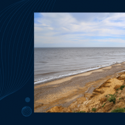
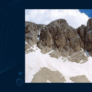
The Polar regions are important to study for a number of reasons. In an era of climate change, melting ice is expected to accelerate sea level change. In the past, various research groups have processed the first 9 years (2010.07-2020) of Cryosat radar altimetry for the Polar Oceans independently, using EarthConsole® or using the G-POD On Demand platform computing services. To continue this vital timeseries up through 2023 and also extend the Polar regions coverage to all regions outside the 50 degree parallel, this project was established.

CryoSSARinSAM+ aims at developing a common processing chain configuration to produce a single, open-access CryoSat-2 altimetry mission dataset that can support radar altimetry research of the polar oceans (both for the northern and southern hemisphere).

This dataset will have a wide range of potential applications, such as studying sea level, circulation, and trends in ice-covered polar seas; improving algorithms to monitor coastal sea level; estimating the thickness of summer sea ice; measuring significant wave height in polar oceans; and enhancing measurements of winter sea ice thickness in the Arctic and Antarctic, among other.

We want this dataset to become a reference standard for the radar altimetry research community, playing a pivotal role in advancing our knowledge of the polar oceans and ice cover, and the impact of climate change on them. A number of research institutions have been onboard designing this study and will directly ingest these data in their ongoing research

Ole B. Andersen
Professor, Department of Space Research and Technology
Geodesy and Earth Observation
DTU SPACE

Project: Assessment of renewable wave energy resources in the coastal zone using high-resolution altimetry products
Research Institution: CENTEC (Centre for Marine Technology and Ocean Engineering), Instituto Superior Tecnico , (Associação do Instituto Superior Técnico para a Investigação e Desenvolvimento) – IST-ID, (Portugal)

The project’s primary objective is to evaluate the potential of wave renewable energy sources in the Atlantic Ocean, with a particular emphasis on the coastal region, where the energy can be efficiently harnessed. To achieve this objective, the project is processing the whole CryoSat, Sentinel-3A, and Sentinel-3B missions data over specific coastal zones and using an improved geophysical retrieval algorithm: SAMOSA+ (Dinardo et al. 2018, Dinardo 2020).

The datasets generated through this project are expected to have a multitude of applications, ranging from evaluating renewable energy sources to gaining a better understanding of the impact of waves on the rise of sea levels. We want this project to benefit the whole altimetry research community, this is why the findings will be shared as we complete the project

Sonia Ponce de Leon A.
Assistant Researcher
CENTEC-IST-University of Lisbon


Why EarthConsole®

EarthConsole® has been selected as the optimal service provider to perform the processing activities requested by the projects.

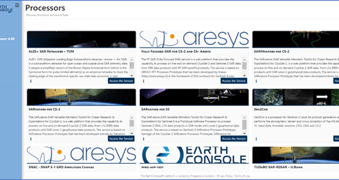
With the ESA Altimetry Virtual Lab (AVL) hosted on the platform, EarthConsole® provides the necessary services and solutions to cater to the specific needs of the altimetry research community.

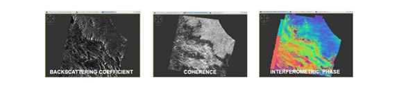
The ESA Altimetry Virtual Lab is hosting SARvatore for CryoSat-2, SARINvatore for CryoSat-2, and SARvatore for Sentinel-3 processors, among others. These processors will be used to reprocess CryoSat-2 altimetry mission data (CryoSSARinSAM+) and Sentinel-3A & Sentinel-3B data (Assessment of renewable wave energy resources in the coastal zone using high-resolution altimetry products) on specific areas and periods of interests indicated by the research institutions.

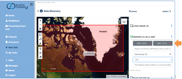
EarthConsole® utilizes flexible computing resources such as Worker Nodes, CPU, and RAM, in combination with a quick access to data on a Copernicus DIAS infrastructure. This minimises the impact of data transfer on processing time, enabling scalable processing campaigns to be completed within the projects’ time constraints.

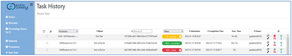
In addition, EarthConsole® experts will oversee all processing activities, freeing up researchers from the task of managing the processing campaign and IT infrastructure, allowing them to focus on their research goals.

In conclusion, EarthConsole® has once again demonstrated its commitment to providing innovative solutions that add value to altimetry research. With the needed processors, flexible computing resources, the quick access to the Copernicus datasets, and the right expertise, researchers can confidently pursue their research objectives, knowing that they have a reliable partner to support their efforts.


P-PRO ON DEMAND

EarthConsole® P-PRO On Demand for fast EO data access and rapid processing

EarthConsole® has been designed to assist users throughout the different phases of their research project, offering support services along the whole process from algorithm development and testing to massive processing campaigns. All this while ensuring a high degree of scalability of the processing capacity to create flexible services which help researchers to:

  1. overcome the need of implementing their processing capability in their own research infrastructure
  2. save costs and time on processing activities and
  3. improve their efficiency on the research project they are undertaking.

With this goal in mind, in early 2022 we have launched P-PRO On Demand, the EarthConsole® service providing the capacity to process online and on-demand EO data from ESA and non-ESA missions. The P-PRO On Demand platform is a flexible platform where you can perform small processing tasks and multiple tests by configuring the area of interest, the time window and customizable processor input parameters according to your requirements and autonomously, thanks to a user-friendly and intuitive interface.

P-PRO On Demand in a nutshell

Choose the processor from a set of ready to use services

In principle, any processor can be integrated in P-PRO and associated with a dedicated ready to use on-demand service (for more info see I-APP). During these first months of operations , upon processor owners’ requests, some integrations have been already successfully carried out. Therefore, at present the P-PRO On Demand application catalogue includes L1b & L2 customisable processors, enabling Sentinel-1 GRD IW and EW, Sentinel-2 L1C, Sentinel-3 SRAL and Cryosat-2 SIRAL SAR & SARin & FF-SAR data processing.

You can select the processor you need to perform your processing tasks from a set of services ready for use:

  • ALES+ SAR Retracker – developed by the Technical University of Munich,
  • FF-SAR (Fully Focused SAR) for CryoSat-2 and Sentinel-3 – developed by Aresys srl,
  • SARINvatore for CS-2, SARvatore for CS-2, SARvatore for S3 – developed by the ESA-ESRIN Altimetry Team
  • TUDaBO SAR-RDSAR – developed by the University of Bonn
  • Sen2CorSNAC – SNAP S-1 GRD Amplitude Change

P-PRO ON DEMAND processing services

And more processors are to come, also provided by users. Thanks to the P-PRO On Demand infrastructure flexibility, it is possible to integrate new processors which are not currently available in the platform. By resorting to the I-APP service, it is possible to request the integration of your own processor, and freely decide to keep it private or share it with the EarthConsole® community.

Select an area of interest and a time window

Next, thanks to the interactive web interface, it is possible to draw an area of interest, select the acquisition time and one of the available input EO data collections.

P-PRO ON DEMAND - area of interest and acquisition time

It is then possible to configure the processor parameters according to your requirements, and submit the task, to launch the processing.

Monitor the whole processing in real time

Following the submission of the job, P-PRO On Demand allows you to monitor the status of the processing tasks in real time and in complete autonomy. Once the processing has been completed you can easily access the task’s log files and results from the task history dashboard.

P-PRO ON DEMAND - Processing Monitoring

How to get started

You can request the service by filling in the form at this link, which will be assessed by our team. Usually each user will be allocated 500 credits (corresponding to 500 processing hours). In case you have specific needs, you can request up to 2200 credits, by specifying the reasoning of your request.

If you have a research, development or pre-commercial project, P-PRO On Demand may be accessible free of charge in the framework of the ESA Network of Resources initiative. Our team provides complete support to submit a sponsorship request for your project, allowing you to benefit from EarthConsole® services at no additional cost for you.

More information is available here.

In addition to the NoR Framework, EarthConsole® services are also available via the OCRE Earth Observation Catalogue for Research. If you are an OCRE EO funding for research winner, EarthConsole® may be selected as a service provider for your research project. More information is available in this blog post we published last March.

For more clarifications, contact us at info@earthconsole.eu.