OCRE Project by CENTEC: more than a decade of processed CryoSat-2 and Sentinel-3 AB data over coastal zones available on ESA Altimetry Virtual Lab
We are pleased to share the conclusion of the European Commission OCRE (Open Clouds for Research Environments) [1] financed project led by CENTEC (Centre for Marine Technology and Ocean Engineering) – Instituto Superior Técnico de Lisboa. With our support here at EarthConsole®, this project aimed at evaluating renewable wave energy resources in the coastal zone, employing advanced high-resolution altimetry products.
CENTEC selected EarthConsole® among the providers of the OCRE Earth Observation catalogue to process data over selected coastal zones and an extensive period of 11 years (from January 2011 to December 2022) for CryoSat-2 data and 7 years (from April 2016 to December 2022) for Sentinel-3 data. The processing was conducted using the ESA-ESRIN SARvatore services for CryoSat-2 and Sentinel-3, which allow users to customise the processing from L1a to L2 data products, and include a list a configurable options such as the one used for this project, the enhanced geophysical retrieval algorithm known as the SAMOSA+ model and retracker.
These services are available for both systematic and on-demand processing via the ESA Altimetry Virtual Lab hosted on EarthConsole®.
The ESA Altimetry Virtual Lab is the virtual space that offers customised services to process Synthetic Aperture Radar Altimetry from CryoSat-2, Sentinel-3 and Sentinel-6 Michael Freilich missions, providing a community space for simplified services access and knowledge-sharing.
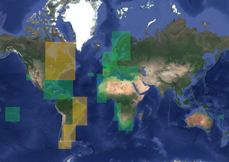
The areas of interest processed for this project are delineated in the accompanying figure below. Green areas represent processing with both CryoSat-2 and Sentinel-3 data, yellow areas are exclusively related to CryoSat-2 data, and blue areas represent processing with Sentinel-3 data.

To download the datasets, we invite you to log into the Altimery Virtual Lab and visit its datasets repository. A free of charge subscription to the Lab will be required in case you are not yet a Lab Member.
We remind you that you could also have the chance to get the costs of the ESA Altimetry Virtual Lab services covered, by requesting a voucher to the ESA Network of Resources.
[1] OCRE receives funding from the European Union’s Horizon 2020 research and innovation programme under grant agreement no. 824079


