
EarthConsole® Stories: Application of Differential SAR interferometry techniques for the estimation of snow properties in the Italian central Apennines area
EarthConsole® Stories are experiences about how we helped universities, research centres or service developers to leverage earth observation data to extract valuable insights for their research, educational or pre-commercial projects.
The Project
Snow-mantle extent (or area), its local thickness (or height) and mass (often expressed by the snow water equivalent, SWE) are the main parameters characterizing snow deposits. Such parameters result of particular importance in meteorology, hydrology, and climate monitoring applications. Anyway, in the general case, the considerable geographical extension of snow layers and their typical spatial heterogeneity makes it impractical to monitor snow by means of direct or indirect in situ measurements, suggesting the exploitation of satellite technologies.
Space-borne SAR sensors, such as those operating in Sentinel-1 mission, are particularly suitable for the analysis of snow deposits, providing data with resolutions up to some meters, with global coverage and 6-day revisit time.
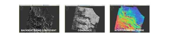
SAR backscattering power coefficient can be used to study the effects of backscattering at the air-snow interface, at the snow-ground interface, together with the volumetric effects of the snow layer. The distinction between wet and dry snow can be obtained exploiting the co-polar and cross-polar SAR returns. Differential Interferometric SAR (DInSAR) can be exploited to analyze the effects of air-snow refraction and the snow-ground reflection, together with the coherence and phase-shifts between two sequential images.
The project activities are oriented towards 4 main objectives:
- development of a processing chain which, starting from the DInSAR measurements available from Sentinel-1, CSK and SAOCOM, together with fusion with auxiliary data from VIS-IR radiometric measurements and physical-electromagnetic SAR response models, using analytical, Bayesian techniques and/or physically-based neural, both able to estimate the snow cover (SCM, Snow Coverage Map), the depth of the snow layer (Snow Pack Depth, SPD) and the equivalent in snow water (Snow Water Equivalent, SWE) in the Central Apennines at a resolution around 100 m;
- creation of a forecast chain that, starting from the SMIVIA (Snow-coverage Modeling, Inversion and Validation using multi-mission multi-frequency Interferometric SAR in central Apennine) products of SCM, SPD and SWE, using the Alpine 3D dynamic snowpack model on the Abruzzo region, forced by forecasting of the Weather Research & Forecasting (WRF) meteorological numerical model and snow precipitation estimates from meteorological radar on the ground, is able to predict in the following 24-48 hours the state of the snowpack and its properties at a resolution of 1-3 km;
- validation of the SCM, SWE and SPD estimates with in-situ measurements on the pilot and verification sites identified in the central Apennines (Gran Sasso and Calderone glacieret, Campo Felice and the mountains of L’Aquila), carried out using multifrequency georadar sensors, radio meteorological remote sensing sensors, chemical-physical sensors and meteo-snow sensors also on the area of the Calderone glacieret;
- application of the processing and forecasting chain to an inflows / outflows model for the management of water resources and to the issuance of the avalanche danger alert over extended regions on the basis of quantitative maps at 24-48 hours in advance.
The Need
Satellite data cover large areas at different resolutions and were considered as the perfect candidates to correct snow cover models using gridded data from coarse to fine resolutions. Optical data for example can give information of snow cover extent and albedo, whereas with DinSAR techniques it is possible to estimate the snow height variation between different dates, or even the snowpack liquid water content.
SAR data processing can be performed in different ways to retrieve snow parameters. SAR backscattering power coefficient can be used to study the effects of backscattering at the air-snow interface, at the snow-ground interface, together with the volumetric effects of the snow layer. The distinction between wet and dry snow can be obtained exploiting the copolar and cross-polar SAR returns. Differential Interferometric SAR (DInSAR) can be exploited to analyze the effects of air-snow refraction and the snow-ground reflection, together with the coherence and phase-shifts between two sequential images.
Why EarthConsole®
The EarthConsole® G-BOX service has been selected for this project and used thanks to a sponsorship received from the ESA Network of Resources initiative.
G-BOX has been chosen since it is a Cloud Virtual Machine (VM) which features high flexibility for the configuration (CPU/RAM/DISK) and provides pre-installed software specific for EO data processing.

The virtual machine proved to be the optimal solution for our data processing needs thanks to the customizable configuration options combined with pre-installed software, global accessibility and embedded access to the datasets offered by the Copernicus Data and Information Access Services – DIAS.
The project impact
The project takes advantage of multi-mission interferometric SAR techniques in L, C, and X bands and focuses attention on a geographic region particularly sensitive to climate change, namely the central Apennines where the southernmost glacier in Europe, the Calderone glacier, is located.
This research might potentially have impact on various aspects of environment and society, including provision of useful information in terms of avalanche warning, monitoring of climate change evolution, flood forecasting and water volumes expected for the hydric supply.
References:
Palermo, E. Raparelli, P. Tuccella, M. Orlandi and F. S. Marzano, “Using Artificial Neural Networks to Couple Satellite C-Band Synthetic Aperture Radar Interferometry and Alpine3D Numerical Model for the Estimation of Snow Cover Extent, Height, and Density,” in IEEE Journal of Selected Topics in Applied Earth Observations and Remote Sensing, vol. 16, pp. 2868-2888, 2023, doi: 10.1109/JSTARS.2023.3253804.

")


 Satellite images © ESA
