EarthConsole® Stories: ESA Arctic+ Salinity project studying freshwater fluxes in the Arctic
EarthConsole® Stories are experiences about how we helped universities, research centres or service developers to leverage earth observation data to extract valuable insights for their research, educational or pre-commercial projects.
The Project
Sea salinity is a key parameter that controls the ocean circulation, and currents are key drivers of the climate of the planet.
Sea Surface Salinity (SSS) serves as a crucial indicator for tracking currents and also freshwater content and fluxes as water with low salt levels can be a sign of freshwater sources like rivers and streams that flow into the ocean. This is especially important in the Arctic region, where significant changes are occurring.
However, it’s important to note that there aren’t many salinity in-situ measurements available in the Arctic region. Due to this scarcity, the use of remote sensing technology to measure salinity, specifically through L-band radiometry satellites like SMOS (Soil Moisture and Ocean Salinity) and SMAP (Soil Moisture Active Passive), becomes particularly important in this area.
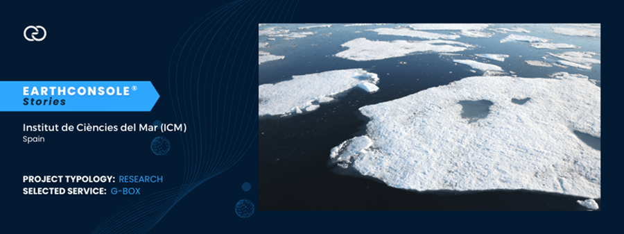
In the Arctic region, accurately measuring Sea Surface Salinity (SSS) is difficult for a couple of reasons. First because the satellites used (L-band satellites) are not as sensitive to changes in salinity in cold waters. Secondly the presence of sea ice complicates matters further as it interferes with satellites readings and requires careful processing.
The ESA Arctic+ Salinity project aims to address these issues and contribute significantly to bridging the knowledge gap regarding changes in freshwater fluxes in the Arctic region.
The Need
As part of the project, the research team needed to develop a new regional Arctic SMOS SSS product with the goal of enhancing two fundamental components for calculating freshwater content in the Arctic:
- Effective spatial resolution: to enhance the clarity of satellite measurements by reducing possible disturbances in the data collected by the satellites;
- Better characterization of the sea surface salinity dynamics: to mitigate the different errors affecting the SMOS measurements taken at different points in time.
To achieve this objective, the team decided to resort to the G-BOX hosting environment service available at EarthConsole®.
The project impact
This project will greatly help the research community. Scientists will get accurate up-to-date maps of salinity dynamics, using data from SMOS and a combination of SMOS and SMAP satellites.
This project has been supported via the ESA Network of Resources initiative.


 Satellite images © ESA


