Posts

EarthConsole® Stories: ESA Arctic+ Salinity project studying freshwater fluxes in the Arctic

EarthConsole® Stories are experiences about how we helped universities, research centres or service developers to leverage earth observation data to extract valuable insights for their research, educational or pre-commercial projects.

The Project

Sea salinity is a key parameter that controls the ocean circulation, and currents are key drivers of the climate of the planet.

Sea Surface Salinity (SSS) serves as a crucial indicator for tracking currents and also freshwater content and fluxes as water with low salt levels can be a sign of freshwater sources like rivers and streams that flow into the ocean. This is especially important in the Arctic region, where significant changes are occurring.

However, it’s important to note that there aren’t many salinity in-situ measurements available in the Arctic region. Due to this scarcity, the use of remote sensing technology to measure salinity, specifically through L-band radiometry satellites like SMOS (Soil Moisture and Ocean Salinity) and SMAP (Soil Moisture Active Passive), becomes particularly important in this area.

In the Arctic region, accurately measuring Sea Surface Salinity (SSS) is difficult for a couple of reasons. First because the satellites used (L-band satellites) are not as sensitive to changes in salinity in cold waters. Secondly the presence of sea ice complicates matters further as it interferes with satellites readings and requires careful processing.

The ESA Arctic+ Salinity project aims to address these issues and contribute significantly to bridging the knowledge gap regarding changes in freshwater fluxes in the Arctic region.

The Need

As part of the project, the research team needed to develop a new regional Arctic SMOS SSS product with the goal of enhancing two fundamental components for calculating freshwater content in the Arctic:

  • Effective spatial resolution: to enhance the clarity of satellite measurements by reducing possible disturbances in the data collected by the satellites;
  • Better characterization of the sea surface salinity dynamics: to mitigate the different errors affecting the SMOS measurements taken at different points in time.

To achieve this objective, the team decided to resort to the G-BOX hosting environment service available at EarthConsole®.

The project impact

This project will greatly help the research community. Scientists will get accurate up-to-date maps of salinity dynamics, using data from SMOS and a combination of SMOS and SMAP satellites.

This project has been supported via the ESA Network of Resources initiative.

Banner including a picture of coastal erosion

EarthConsole® Stories: HYDROCOASTAL project enhancing the understanding of river discharge-coastal sea levels interactions

EarthConsole® Stories are experiences about how we helped universities, research centres or service developers to leverage earth observation data to extract valuable insights for their research, educational or pre-commercial projects.

The Project

With funding from the European Space Agency (ESA), the Hydrocoastal project aims at making the most of SAR and SARin altimeter measurements in coastal areas and inland waters. To accomplish this goal, the project seeks to explore and implement novel methodologies for processing SAR and SARin data obtained from CryoSat-2, as well as SAR altimeter data gathered from Sentinel-3A and Sentinel-3B satellites.

An important focus of the project is to enhance the comprehension of the relationship between river discharge and coastal sea levels. To facilitate this understanding, the research team developed, implemented, and assessed new SAR and SARIn processing algorithms. From the results of this evaluation a processing scheme has been implemented to generate global coastal zone and river discharge data sets. The potential impact and benefits of these datasets will then be investigated through a series of impact assessment case studies.

Furthermore, as part of promoting collaboration and knowledge sharing, all generated datasets will be made available upon request to external researchers, fostering further exploration and analysis in related fields.

The Need

The Hydrocoastal project has developed a delay-doppler processor in Python. This processor can take Sentinel-3 SRAL L1A and Cryosat-2 FBR data and turn it into L1B data in a customised netCDF format. These data products were additionally extended to include data from Sentinel-3 and Cryosat-2 L2 files.

In the earlier phase of the project, the team developed different retracking tools that could work with these products. These tools were tested and compared with the goal of selecting a single retracking solution. Only the selected tool was to be applied to the data products created by the Python delay-doppler processor.

At this point the research team needed a suitable solution to perform these processing steps and generate the global coastal zone and river discharge datasets and resorted to GBOX (Integrated Algorithm and Execution Environment) available via the ESA Altimetry Virtual Lab hosted on EarthConsole®.

Why EarthConsole®

The Team resorted to EarthConsole® G-BOX as it offered the necessary computing resources to efficiently deliver the global validated coastal zone datasets and river discharge datasets.

The initial phase of the project, involving the definition of products and assessment of various algorithms, has been successfully completed internally. For the next phase involving the generation of the datasets, we selected EarthConsole® G-BOX for its potential to significantly expedite our data processing timeline compared to our in-house facilities. By leveraging G-BOX, we eliminated the lengthy process of downloading input data. This enabled us to deliver the global datasets in a much shorter time, meeting our project goals effectively.

The project impact

The ESA Hydrocoastal project has the ambition to utilize the global datasets to foster more effective management strategies for various coastal regions. These areas have common features such as flooding and erosion, sedimentation, the importance of accurate high resolution local modelling, the vulnerability of coastal habitats, the connection between river discharge and coastal sea levels.

Simultaneously, the project focuses on investigating the potential for operational hydrological forecasting in inland water systems, assessing the influence of lake size and riverbank configuration on water level retrieval accuracy, quantifying the freshwater inflow into the seas under examination, and developing a comprehensive global water level climatology.

This project has been supported via the ESA Network of Resources initiative.

Banner including a picture of the Calderone Glacier

EarthConsole® Stories: Application of Differential SAR interferometry techniques for the estimation of snow properties in the Italian central Apennines area

EarthConsole® Stories are experiences about how we helped universities, research centres or service developers to leverage earth observation data to extract valuable insights for their research, educational or pre-commercial projects.


The Project

Snow-mantle extent (or area), its local thickness (or height) and mass (often expressed by the snow water equivalent, SWE) are the main parameters characterizing snow deposits. Such parameters result of particular importance in meteorology, hydrology, and climate monitoring applications. Anyway, in the general case, the considerable geographical extension of snow layers and their typical spatial heterogeneity makes it impractical to monitor snow by means of direct or indirect in situ measurements, suggesting the exploitation of satellite technologies.

Space-borne SAR sensors, such as those operating in Sentinel-1 mission, are particularly suitable for the analysis of snow deposits, providing data with resolutions up to some meters, with global coverage and 6-day revisit time.

SAR backscattering power coefficient can be used to study the effects of backscattering at the air-snow interface, at the snow-ground interface, together with the volumetric effects of the snow layer. The distinction between wet and dry snow can be obtained exploiting the co-polar and cross-polar SAR returns. Differential Interferometric SAR (DInSAR) can be exploited to analyze the effects of air-snow refraction and the snow-ground reflection, together with the coherence and phase-shifts between two sequential images.

The project activities are oriented towards 4 main objectives:

  1. development of a processing chain which, starting from the DInSAR measurements available from Sentinel-1, CSK and SAOCOM, together with fusion with auxiliary data from VIS-IR radiometric measurements and physical-electromagnetic SAR response models, using analytical, Bayesian techniques and/or physically-based neural, both able to estimate the snow cover (SCM, Snow Coverage Map), the depth of the snow layer (Snow Pack Depth, SPD) and the equivalent in snow water (Snow Water Equivalent, SWE) in the Central Apennines at a resolution around 100 m;
  2. creation of a forecast chain that, starting from the SMIVIA (Snow-coverage Modeling, Inversion and Validation using multi-mission multi-frequency Interferometric SAR in central Apennine) products of SCM, SPD and SWE, using the Alpine 3D dynamic snowpack model on the Abruzzo region, forced by forecasting of the Weather Research & Forecasting (WRF) meteorological numerical model and snow precipitation estimates from meteorological radar on the ground, is able to predict in the following 24-48 hours the state of the snowpack and its properties at a resolution of 1-3 km;
  3. validation of the SCM, SWE and SPD estimates with in-situ measurements on the pilot and verification sites identified in the central Apennines (Gran Sasso and Calderone glacieret, Campo Felice and the mountains of L’Aquila), carried out using multifrequency georadar sensors, radio meteorological remote sensing sensors, chemical-physical sensors and meteo-snow sensors also on the area of the Calderone glacieret;
  4. application of the processing and forecasting chain to an inflows / outflows model for the management of water resources and to the issuance of the avalanche danger alert over extended regions on the basis of quantitative maps at 24-48 hours in advance.

Backscattering coefficient, Coherence and Interferometric Phase

The Need

Satellite data cover large areas at different resolutions and were considered as the perfect candidates to correct snow cover models using gridded data from coarse to fine resolutions. Optical data for example can give information of snow cover extent and albedo, whereas with DinSAR techniques it is possible to estimate the snow height variation between different dates, or even the snowpack liquid water content.

SAR data processing can be performed in different ways to retrieve snow parameters. SAR backscattering power coefficient can be used to study the effects of backscattering at the air-snow interface, at the snow-ground interface, together with the volumetric effects of the snow layer. The distinction between wet and dry snow can be obtained exploiting the copolar and cross-polar SAR returns. Differential Interferometric SAR (DInSAR) can be exploited to analyze the effects of air-snow refraction and the snow-ground reflection, together with the coherence and phase-shifts between two sequential images.

Why EarthConsole®

The EarthConsole® G-BOX service has been selected for this project and used thanks to a sponsorship received from the ESA Network of Resources initiative.

G-BOX has been chosen since it is a Cloud Virtual Machine (VM) which features high flexibility for the configuration (CPU/RAM/DISK) and provides pre-installed software specific for EO data processing.

Picture of Gianluca Palermo, PostDoc Researcher at Sapienza University

The virtual machine proved to be the optimal solution for our data processing needs thanks to the customizable configuration options combined with pre-installed software, global accessibility and embedded access to the datasets offered by the Copernicus Data and Information Access Services – DIAS.

The project impact

The project takes advantage of multi-mission interferometric SAR techniques in L, C, and X bands and focuses attention on a geographic region particularly sensitive to climate change, namely the central Apennines where the southernmost glacier in Europe, the Calderone glacier, is located.

This research might potentially have impact on various aspects of environment and society, including provision of useful information in terms of avalanche warning, monitoring of climate change evolution, flood forecasting and water volumes expected for the hydric supply.


References:

Palermo, E. Raparelli, P. Tuccella, M. Orlandi and F. S. Marzano, “Using Artificial Neural Networks to Couple Satellite C-Band Synthetic Aperture Radar Interferometry and Alpine3D Numerical Model for the Estimation of Snow Cover Extent, Height, and Density,” in IEEE Journal of Selected Topics in Applied Earth Observations and Remote Sensing, vol. 16, pp. 2868-2888, 2023, doi: 10.1109/JSTARS.2023.3253804.

4 reasons why educators should bring Earth Observation to high school

4 reasons why educators should bring Earth Observation to high school

From the devastating impacts of climate change to the unprecedented loss of biodiversity, it’s clear that the health of our planet is a top priority. As we continue to grapple with these complex environmental challenges, it’s becoming increasingly apparent that the solutions will require a multifaceted approach. From policy changes to technological innovations, there are many paths forward that should not overlook the role of education.

In order to address the increasing environmental challenges we face, we must equip students with the knowledge and skills to create a sustainable future for all.

That’s where earth observation comes in.

By leveraging the power of earth observation data and technology, educators can provide students with the relevant skills to better keep track of the dynamics of our planet.

If you are new to earth observation, a definition is necessary: Earth Observation is defined as the process of acquiring observations of the Earth’s surface and atmosphere via remote sensing instruments, for example satellites or drones1. This field plays a crucial role in understanding the planet, monitoring and mitigating climate change, preventing natural disasters such as earthquakes, floods or fires, and better managing natural resources.

If you’re a school administrator or a teacher here are the 4 reasons why incorporating Earth Observation training into the school curricula is essential to prepare students to become informed and prepared citizens who are ready to act for environmental protection.

Reason #1 Earth Observation will enable your students to be environmentally aware and make a difference.

With the growing availability of satellite data and the free and open data policies, satellite observations can be considered more and more as a valuable source of information to monitor actions on the sustainable development of our planet.

For instance this is what is stated in the ESA Compendium of EO contributions to the SDG Targets and Indicators2. Satellite data can bring a relevant contribution in measuring progress towards many Sustainable Development Goals. Guaranteeing the supply of EO data and ensuring capacity to use such data are critical steps that can help countries in setting their SDG targets and monitor progress.

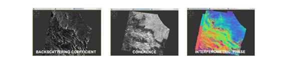
By bringing earth observation into the classroom, your students will try their hand at developing applications that extract value-added information for monitoring environmental, climate and/or land resources.

Reason #2 Your students will get familiar with cutting edge technologies.

Teaching information extraction techniques from satellites data goes hand in hand with the use of advanced technologies.

New information technologies are revolutionising the way we manage the vast amount of data from satellite missions to address environmental challenges. The advent of cloud environments represents a crucial breakthrough: users no longer have to spend time and resources downloading data to their computer for processing but can access them directly on the cloud to analyse them more efficiently.

In addition, cloud environments co-locate computing power and data, allowing to perform data processing and analysis tasks with a scalable capacity, even in the order of petabytes.

For example, here at EarthConsole® we offer virtual machines that can help your students try their hand at building algorithms that run on Earth observation datasets. The virtual machine comes with pre-installed software for earth observation data exploitation and can be easily configured with the same settings for an entire classroom, allowing students to use it from anywhere and with their own devices.

This technological revolution represents an unprecedented opportunity that opens new horizons for the development of innovative and efficient solutions to tackle climate change and better manage natural resources.

Reason #3 You will orientate your students towards STEM Education

Earth Observation data specialists can have differentiated university backgrounds ranging from engineering to computer science and mathematics. Integrating earth observation into your curricula could be an excellent way to broaden the prospects for choosing a university and/or professional path in the STEM field (Science, Technology, Engineers and Mathematics).

Also, let’s not forget that supporting STEM Education could help addressing the gender and diversity gap in science and technology fields. According to the UNESCO Science Report 20213, women make up only 28% of engineering graduates and 40% of those in computer science. Encouraging and supporting underrepresented groups to pursue STEM education and careers can help to bridge this gap and ensure a diverse and inclusive workforce.

Reason #4 There is high-demand for Data Specialists

The Earth Observation industry is growing, with a rapidly expanding market and increasing demand for advanced technologies, services and thus professionals.

The EUSPA EO and GNSS Market Report 20224 states that Earth Observation data and service revenues are set to double from roughly €2.8 billion to over €5.5 billion over the next decade.

The market for Earth Observation applications is boosted by a large pool of value-added services contributing to the most variegated market segments ranging from Climate Services to Urban Development and Cultural Heritage, Agriculture, Energy and Raw Materials and the Insurance and Finance Segment.

With the industry, the demand for specialized workforce grows as well.

As highlighted in the LinkedIn Jobs on the Rise Report 2023, Data Engineer is one of the fastest-growing job titles in Europe over the past five years. Data engineers specialize in developing tools for collecting and analyzing large volumes of data, to address complex challenges and aid decision-making.

In conclusion, Earth Observation is a powerful tool that educators should consider bringing into their high school classrooms. By incorporating Earth Observation technologies and data into their curricula, educators can provide students with hands-on learning experiences that enhance their understanding of the natural world and help develop essential skills.

With the potential to inspire and engage students in science and technology, Earth Observation has the power to make a lasting impact on the next generations.


1 ESA Newcomers Earth Observation Guide https://business.esa.int/newcomers-earth-observation-guide
2 EARTH OBSERVATION FOR SDG “Compendium of Earth Observation contributions to the SDG Targets and Indicators” https://eo4society.esa.int/wp-content/uploads/2021/01/EO_Compendium-for-SDGs.pdf
3 UNESCO Science Report 2021: The race against time for smarter development https://www.unesco.org/reports/science/2021/en/download-report
4 The EUSPA Earth Observation (EO) & Global Navigation Satellite System (GNSS) Market Report https://www.euspa.europa.eu/sites/default/files/uploads/euspa_market_report_2022.pdf

We provide the technology you need to deliver earth observation trainings to your students

Contact Us