4 reasons why educators should bring Earth Observation to high school

4 reasons why educators should bring Earth Observation to high school

From the devastating impacts of climate change to the unprecedented loss of biodiversity, it’s clear that the health of our planet is a top priority. As we continue to grapple with these complex environmental challenges, it’s becoming increasingly apparent that the solutions will require a multifaceted approach. From policy changes to technological innovations, there are many paths forward that should not overlook the role of education.

In order to address the increasing environmental challenges we face, we must equip students with the knowledge and skills to create a sustainable future for all.

That’s where earth observation comes in.

By leveraging the power of earth observation data and technology, educators can provide students with the relevant skills to better keep track of the dynamics of our planet.

If you are new to earth observation, a definition is necessary: Earth Observation is defined as the process of acquiring observations of the Earth’s surface and atmosphere via remote sensing instruments, for example satellites or drones1. This field plays a crucial role in understanding the planet, monitoring and mitigating climate change, preventing natural disasters such as earthquakes, floods or fires, and better managing natural resources.

If you’re a school administrator or a teacher here are the 4 reasons why incorporating Earth Observation training into the school curricula is essential to prepare students to become informed and prepared citizens who are ready to act for environmental protection.

Reason #1 Earth Observation will enable your students to be environmentally aware and make a difference.

With the growing availability of satellite data and the free and open data policies, satellite observations can be considered more and more as a valuable source of information to monitor actions on the sustainable development of our planet.

For instance this is what is stated in the ESA Compendium of EO contributions to the SDG Targets and Indicators2. Satellite data can bring a relevant contribution in measuring progress towards many Sustainable Development Goals. Guaranteeing the supply of EO data and ensuring capacity to use such data are critical steps that can help countries in setting their SDG targets and monitor progress.

By bringing earth observation into the classroom, your students will try their hand at developing applications that extract value-added information for monitoring environmental, climate and/or land resources.

Reason #2 Your students will get familiar with cutting edge technologies.

Teaching information extraction techniques from satellites data goes hand in hand with the use of advanced technologies.

New information technologies are revolutionising the way we manage the vast amount of data from satellite missions to address environmental challenges. The advent of cloud environments represents a crucial breakthrough: users no longer have to spend time and resources downloading data to their computer for processing but can access them directly on the cloud to analyse them more efficiently.

In addition, cloud environments co-locate computing power and data, allowing to perform data processing and analysis tasks with a scalable capacity, even in the order of petabytes.

For example, here at EarthConsole® we offer virtual machines that can help your students try their hand at building algorithms that run on Earth observation datasets. The virtual machine comes with pre-installed software for earth observation data exploitation and can be easily configured with the same settings for an entire classroom, allowing students to use it from anywhere and with their own devices.

This technological revolution represents an unprecedented opportunity that opens new horizons for the development of innovative and efficient solutions to tackle climate change and better manage natural resources.

Reason #3 You will orientate your students towards STEM Education

Earth Observation data specialists can have differentiated university backgrounds ranging from engineering to computer science and mathematics. Integrating earth observation into your curricula could be an excellent way to broaden the prospects for choosing a university and/or professional path in the STEM field (Science, Technology, Engineers and Mathematics).

Also, let’s not forget that supporting STEM Education could help addressing the gender and diversity gap in science and technology fields. According to the UNESCO Science Report 20213, women make up only 28% of engineering graduates and 40% of those in computer science. Encouraging and supporting underrepresented groups to pursue STEM education and careers can help to bridge this gap and ensure a diverse and inclusive workforce.

Reason #4 There is high-demand for Data Specialists

The Earth Observation industry is growing, with a rapidly expanding market and increasing demand for advanced technologies, services and thus professionals.

The EUSPA EO and GNSS Market Report 20224 states that Earth Observation data and service revenues are set to double from roughly €2.8 billion to over €5.5 billion over the next decade.

The market for Earth Observation applications is boosted by a large pool of value-added services contributing to the most variegated market segments ranging from Climate Services to Urban Development and Cultural Heritage, Agriculture, Energy and Raw Materials and the Insurance and Finance Segment.

With the industry, the demand for specialized workforce grows as well.

As highlighted in the LinkedIn Jobs on the Rise Report 2023, Data Engineer is one of the fastest-growing job titles in Europe over the past five years. Data engineers specialize in developing tools for collecting and analyzing large volumes of data, to address complex challenges and aid decision-making.

In conclusion, Earth Observation is a powerful tool that educators should consider bringing into their high school classrooms. By incorporating Earth Observation technologies and data into their curricula, educators can provide students with hands-on learning experiences that enhance their understanding of the natural world and help develop essential skills.

With the potential to inspire and engage students in science and technology, Earth Observation has the power to make a lasting impact on the next generations.


1 ESA Newcomers Earth Observation Guide https://business.esa.int/newcomers-earth-observation-guide
2 EARTH OBSERVATION FOR SDG “Compendium of Earth Observation contributions to the SDG Targets and Indicators” https://eo4society.esa.int/wp-content/uploads/2021/01/EO_Compendium-for-SDGs.pdf
3 UNESCO Science Report 2021: The race against time for smarter development https://www.unesco.org/reports/science/2021/en/download-report
4 The EUSPA Earth Observation (EO) & Global Navigation Satellite System (GNSS) Market Report https://www.euspa.europa.eu/sites/default/files/uploads/euspa_market_report_2022.pdf

We provide the technology you need to deliver earth observation trainings to your students

Contact Us
EarthConsole: Our earth observation data processing platform in brief

New to EarthConsole®? Our earth observation data processing platform in brief

We often receive many questions about how to start with our services and how to use them at no charge. We have collected some of the answers to your questions in this post.

If you need extra clarifications, drop us an email at info@earthconsole.eu.

Request service

What is EarthConsole® for?

EarthConsole® is a cloud-based platform to ease the exploitation of earth observation data. Thanks to its computing power co-located with EO data archives, it offers support solutions from developing algorithms to bulk processing, and everything that is between.

Let’s take a deeper look at what they are for:

  • G-BOX Algorithm Development and Execution Environment: you can develop and test your algorithm and do post-processing analysis on a virtual machine with fast access to the Copernicus DIAS datasets and pre-installed software.
  • I-APP Application Integration Service: either you have developed your algorithm or you wish to use a third party application for processing, you can rely on our expert support to integrate it into the EarthConsole® environment for massive processing.
  • P-PRO Parallel Processing Service: you will be enabled to scale up your processing campaign on a wider area of interest and time window.
  • P-PRO ON DEMAND Parallel Processing on Demand: to manage small processing tasks via the user-friendly interface of our P-PRO ON DEMAND platform.

EarthConsole® supports the principles of a User-Centred Design approach. We focus on our users’ needs in all phases of the development of the platform. We always have an ear to listen to your feedback to evolve our solutions.

Who should use EarthConsole®?

EarthConsole® is for all those who need to process earth observation data in the R&D phase of their project. For sure researchers, PhDs, the stakeholders orbiting around ESA and national space agencies are the primary beneficiaries of EarthConsole®. But our services are not limited to these typologies of users.

Startups innovators and entrepreneurs not belonging to the earth observation domain can also take advantage of our services. For example, they can receive training in the pre-commercial phase of their project to better learn how to use satellite data to develop new services with high-commercial value.

Let’s not forget about universities and their students. The data scientist is one of the most fast-growing occupations. We are in the position to offer training experiences providing a solid preparation on the Copernicus satellites sensors, characteristics, data typologies and their main applications.

Plus, G-BOX enables mass configuration of tens of virtual machines with the same settings which you can access from any location and any OS (Windows, Linux, MAC). This makes it the ideal solution for a class of students intending to improve their skills with the development of earth observation applications.

Which are the processors ready for use?

We have a list of processors for Altimetry, SAR and Optical applications, integrated and ready to use either for bulk and/or on-demand processing:

And if the processor you need is not there, you can ask us to integrate it with the I-APP service. EarthConsole® allows to integrate in principle any processor also coming from other platforms. And you can in any moment decide to share the processor with other users or keep it for your use only.

How to receive a voucher for using EarthConsole®?

Well yes, you may use our services at no charge for you or your institution. Our solutions are on the ESA EO Network of Resources (NoR), an initiative to foster the use of cloud environments. If you have a research, educational or pre-commercial project, you can ask for a voucher which may totally cover the costs of our services.

The process to request the voucher is very simple, and we will be there to guide you step by step.

But you may be wondering what happens if the sponsorship application at NoR is not successful.
You don’t have to worry because you won’t have to buy the service at your own expenses if you don’t want to. You will be able to withdraw your service request, without any penalty.

How can you start?

First you must request the service you need through our webapp. We will receive your request and do our assessment to offer the solution that best fits your needs.

In case you will select the NoR sponsorship option, we will provide you with the voucher request form filled in for your approval and signature. If it is ok, you will have to submit it to NoR and wait for the evaluation.

In case of acceptance, we will contact you to start using EarthConsole® services.

As easy as it sounds!

EarthConsole 2021-2022

One year of EarthConsole®
Figures 2021/2022

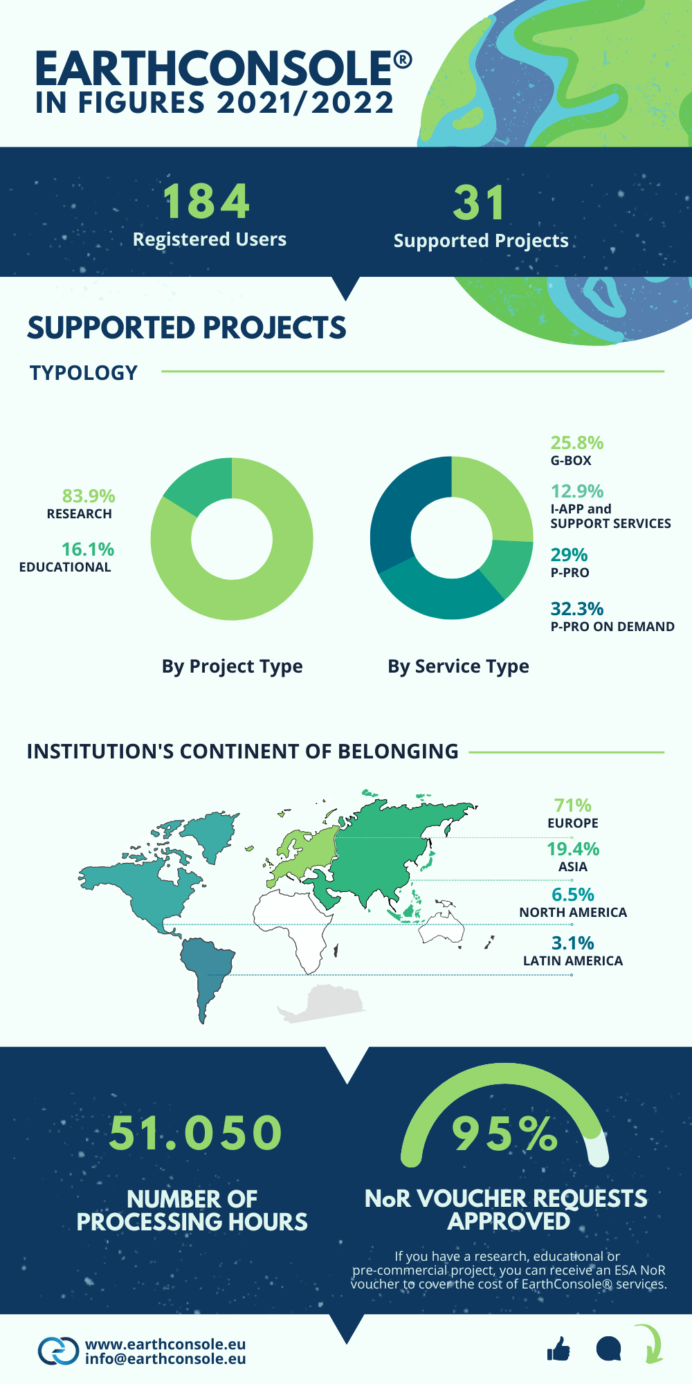
July marked EarthConsole®’s first year of operations. This infographic shows some figures on the projects we supported with our processing solutions for earth observation data.

One year of EarthConsole

Following in the footsteps of ESA RSS’s success Progressive Systems operated until June 2021, the first year confirmed EarthConsole® was able to respond to the needs of different research communities in all the phases of their research process. The platform has also proven to be an effective solution for educators and students. This is because EarthConsole® offers solutions ranging from algorithm development and testing to scalable massive processing campaigns, and all that’s in between. All these solutions are flexible, customizable, and scalable to meet the users’ requirements.

The user-centred evolution of our solutions is one of the founding principles of EarthConsole®. With the objective of responding to the emerging needs of our users’ community, the platform was enriched with virtual laboratories dedicated to specific communities of earth observers (see Virtual Labs). Ad hoc processing services are made available in a virtual space, through which it is also possible to network with colleagues and exchange information through forums, a repository of datasets and much more.

We remind you that if you are conducting research or have a pre-commercial or educational project, the ESA Network of Resources can grant you a voucher to access our services free of charge.

Join our community of 180+ registered users now, request a service here and we will support you all the way to submit a sponsorship application for your project to NoR.

P-PRO ON DEMAND

EarthConsole® P-PRO On Demand for fast EO data access and rapid processing

EarthConsole® has been designed to assist users throughout the different phases of their research project, offering support services along the whole process from algorithm development and testing to massive processing campaigns. All this while ensuring a high degree of scalability of the processing capacity to create flexible services which help researchers to:

  1. overcome the need of implementing their processing capability in their own research infrastructure
  2. save costs and time on processing activities and
  3. improve their efficiency on the research project they are undertaking.

With this goal in mind, in early 2022 we have launched P-PRO On Demand, the EarthConsole® service providing the capacity to process online and on-demand EO data from ESA and non-ESA missions. The P-PRO On Demand platform is a flexible platform where you can perform small processing tasks and multiple tests by configuring the area of interest, the time window and customizable processor input parameters according to your requirements and autonomously, thanks to a user-friendly and intuitive interface.

P-PRO On Demand in a nutshell

Choose the processor from a set of ready to use services

In principle, any processor can be integrated in P-PRO and associated with a dedicated ready to use on-demand service (for more info see I-APP). During these first months of operations , upon processor owners’ requests, some integrations have been already successfully carried out. Therefore, at present the P-PRO On Demand application catalogue includes L1b & L2 customisable processors, enabling Sentinel-1 GRD IW and EW, Sentinel-2 L1C, Sentinel-3 SRAL and Cryosat-2 SIRAL SAR & SARin & FF-SAR data processing.

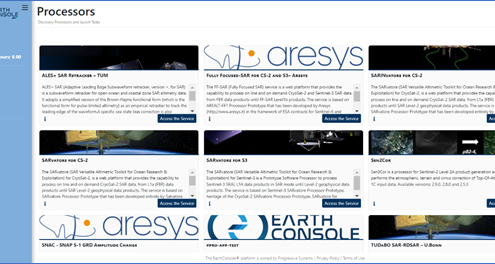
You can select the processor you need to perform your processing tasks from a set of services ready for use:

  • ALES+ SAR Retracker – developed by the Technical University of Munich,
  • FF-SAR (Fully Focused SAR) for CryoSat-2 and Sentinel-3 – developed by Aresys srl,
  • SARINvatore for CS-2, SARvatore for CS-2, SARvatore for S3 – developed by the ESA-ESRIN Altimetry Team
  • TUDaBO SAR-RDSAR – developed by the University of Bonn
  • Sen2CorSNAC – SNAP S-1 GRD Amplitude Change

P-PRO ON DEMAND processing services

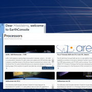
And more processors are to come, also provided by users. Thanks to the P-PRO On Demand infrastructure flexibility, it is possible to integrate new processors which are not currently available in the platform. By resorting to the I-APP service, it is possible to request the integration of your own processor, and freely decide to keep it private or share it with the EarthConsole® community.

Select an area of interest and a time window

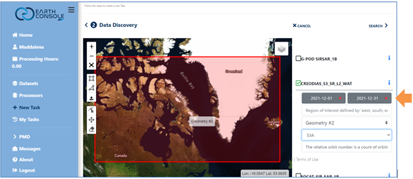
Next, thanks to the interactive web interface, it is possible to draw an area of interest, select the acquisition time and one of the available input EO data collections.

P-PRO ON DEMAND - area of interest and acquisition time

It is then possible to configure the processor parameters according to your requirements, and submit the task, to launch the processing.

Monitor the whole processing in real time

Following the submission of the job, P-PRO On Demand allows you to monitor the status of the processing tasks in real time and in complete autonomy. Once the processing has been completed you can easily access the task’s log files and results from the task history dashboard.

P-PRO ON DEMAND - Processing Monitoring

How to get started

You can request the service by filling in the form at this link, which will be assessed by our team. Usually each user will be allocated 500 credits (corresponding to 500 processing hours). In case you have specific needs, you can request up to 2200 credits, by specifying the reasoning of your request.

If you have a research, development or pre-commercial project, P-PRO On Demand may be accessible free of charge in the framework of the ESA Network of Resources initiative. Our team provides complete support to submit a sponsorship request for your project, allowing you to benefit from EarthConsole® services at no additional cost for you.
More information is available here.

In addition to the NoR Framework, EarthConsole® services are also available via the OCRE Earth Observation Catalogue for Research. If you are an OCRE EO funding for research winner, EarthConsole® may be selected as a service provider for your research project. More information is available in this blog post we published last March.

For more clarifications, contact us at info@earthconsole.eu.

EarthConsole® on the OCRE Earth Observation Catalogue for Research

EarthConsole® has been registered in the OCRE Earth Observation (EO) Catalogue for Research and its offering may now be selected by EO funding for research winners.

OCRE (Open Clouds for Research Environments) is a Horizon 2020 project funded by the European Union that aims to enable and facilitate research institutions to use commercial digital services in a safe and easy manner.

EO and cloud-based services offer the European research community a wealth of powerful tools, but for many researchers, these are currently out of reach, with suitable services difficult to find and select.

The OCRE project wants to address this need by making it easier to procure both Cloud and EO services. The EO Catalogue is a key result of such a project which aims to create a digital single marketplace for commercial EO and Cloud services for research in Europe.

The Earth Observation Catalogue is a useful tool for EO Funding for Research winners to find validated cloud and digital services which respond to the research and education communities’ requirements, saving institutions the time-consuming and complex process of doing this by themselves. For each of the EO Funding for Research winners, at least three of the EO companies in the OCRE EO Catalogue will be shortlisted to choose from. Then, based on the requirements and criteria of the research project and the response from these suppliers, a provider will be awarded, fulfilling the minimum requirements for a fair procurement.

Find us in the catalogue!

The EarthConsole® Virtual Lab for the Altimetry community

The EarthConsole® Altimetry Virtual Lab, funded by ESA, aims at providing a virtual space to:

  • Support the Altimetry community in the development & operation of new Earth Observation applications;
  • Foster collaboration by leveraging on knowledge-sharing tools.

The Altimetry Virtual Lab has been developed on the new EarthConsole® platform and hosts the SARvatore (SAR Versatile Altimetric TOolkit for Research & Exploitation) family of processors which was previously available in the ESA Grid Processing On-Demand (G-POD) environment. The Altimetry Virtual Lab ensures service continuity following the recent termination of the G-POD environment.

The driving concept is to offer the same processing capabilities formerly available in ESA G-POD while improving the user experience by combining:

  • The access to innovative, fully customizable, altimetry data processing services from a single environment at the push of a button;
  • The availability of a set of tools to network with colleagues, keep up with the latest news and publications on radar altimetry, and share results to avoid duplication of efforts;
  • The flexibility of a virtual space which can be further reshaped following the future emerging needs of the community.

In particular, Altimetry Virtual Lab users can:

  1. Request & access, through the G-BOX service, a virtual machine for algorithm development, testing and post-processing analysis. Each virtual machine also includes software for altimetry data analysis & visualization: BRAT (http://www.altimetry.info/toolbox/), Panoply (https://www.giss.nasa.gov/tools/panoply/) and Python;
  2. Request to access and process data with the following processors which have been integrated and are ready for use:
    • ALES+ SAR Retracker – developed by the Technical University of Munich,
    • FF-SAR (Fully Focused SAR) for CryoSat-2 – developed by Aresys srl,
    • SARINvatore for CS-2, SARvatore for CS-2, SARvatore for S3 – developed by the ESA-ESRIN Altimetry Team
    • TUDaBO SAR-RDSAR – developed by the University of Bonn.
      All processors can be requested for both bulk (P-PRO service) or on-demand (P-PRO ON DEMAND service) processing;
  3. Request to integrate, through the I-APP service, additional processors;
  4. Access a set of tools to network and share information and results with colleagues: a forum, a datasets repository, and a knowledge-base with relevant altimetry publications and media for consultation;

Jérôme Benveniste, the initiator and coordinator of the GPOD/SARvatore service and its migration to the EarthConsole®, commented:

The GPOD/SARvatore Altimetry processing on-demand tool has been a great success fostering more than 25 peer-reviewed publications, 3 PhD thesis and tens of presentations to conferences in the past six years. Thanks to this SARvatore Family framework supported by ESA, several new and innovative altimetry retrackers were developed going beyond the standard Ground Segment algorithms, some by ESA, some donated by users, and were made accessible to worldwide Altimetry users, for breakthrough research in the oceanic coastal zone, inland water and the cryosphere domains. It was clear to ESA that, albeit the obsolescence of the GPOD, this adventure had to be continued and supported. I wish great success to the new EarthConsole® Altimetry Virtual Lab environment, which I’m sure will be a change of gears in efficiency and attractiveness to users.

The Altimetry Virtual Lab intends to lead the way for further virtual labs dedicated to other Earth observation communities and foster interdisciplinarity among them to advance collaboratively in the Earth observation sector.

Access to the Altimetry Virtual Lab web site is free of charge . If you are a former SARvatore G-POD data user or an altimetry data user, please visit this page for detailed instructions to join the EarthConsole® Altimetry Virtual Lab.

All the Altimetry Virtual Lab services are available via the ESA EO Network of Resources initiative. Users with a research, development, pre-commercial, or educational project, may be eligible to apply for an ESA sponsorship and receive a voucher to access these services free of charge or at very competitive prices.
Any request for information related to the Altimetry Virtual Lab should be sent to info@earthconsole.eu with support@earthconsole.eu and altimetry.info@esa.int in cc.

We look forward to welcoming you to the Lab!

Progressive Systems launches EarthConsole™

The all-in-one-solution to make the most of Earth Observation Data

An all-in-one cloud-based platform to assist researchers, innovators and service providers in optimizing the way in which they exploit Earth Observation data to analyse and keep track of our changing planet.

This is EarthConsole™, the new platform of Progressive Systems bringing Earth Observation data access, algorithm development, integration and processing services, analysis and visualization tools, powerful computing resources and high-speed network connections, all in one place. A comprehensive service which builds on the consolidated experience of the Research and Service Support (RSS) service Progressive Systems has operated for more than a decade on behalf of ESA, and which has supported hundreds of EO data users all over the world.

EarthConsole™ offers three main solutions:

  • G-BOX: an environment enabling users to develop and test algorithms, providing a virtual machine on a cloud infrastructure with fast access to Earth Observation data, customizable and flexible computing resources which is accessible from any location, any device and at any time;
  • P-PRO: the parallel processing service, allowing to process huge volumes of data in a faster and efficient manner thanks to a reliable cloud-based technology able to optimise the computing resources ;
  • I-APP: the application integration service of EarthConsole™, providing expert support to prepare software for integration in the Parallel Processing environment for massive processing.

All EarthConsole™ solutions offer a high degree of flexibility as they are customizable to a diverse extent on users’ needs.

The “Bring User to Data” has been one of key success factors of RSS and it will be a key pillar of the EarthConsole™ platform as well. But our objective with EarthConsole™ is to take it a step further and implement a user-centred evolution process. Users are encouraged to share their feedback, inputs and requirements on the platform with the objective of integrating these emerging customers-generated ideas into future developments of EarthConsole ™ .

declared Giancarlo Rivolta, CEO at Progressive Systems.

EarthConsole™ services are also available via the Network of EO Resources, a new ESA initiative enabling EO data users to procure and compare cloud-based services. Users with a research, development or pre-commercial project may receive an ESA voucher to benefit from EarthConsole™ services free of charge or at very advantageous prices.