
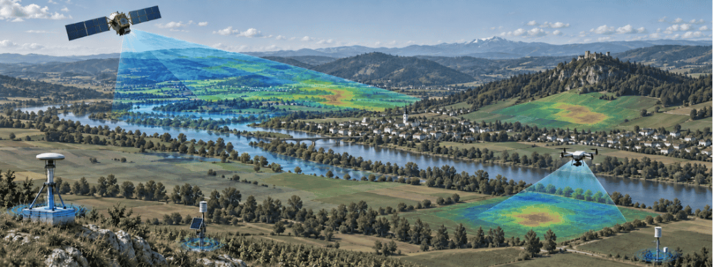
No single source tells the whole story: why satellite data often works best when combined with other observations
Satellite technology is remarkably advanced, so it is tempting to imagine it can see almost anything, anywhere, in perfect detail, at any moment. In reality, satellites have real limits.
Most Earth Observation satellites follow predetermined orbits, which limit when they can observe a particular location. Some can be tasked or pointed towards a target, but acquisitions are still constrained by their orbit, capacity and revisit time. Thick cloud cover can prevent optical instruments from observing the surface, while thinner clouds and haze may reduce data quality. Radar can image the surface through most cloud cover and operate day or night, although intense precipitation can affect some radar observations, depending on the wavelength and application. Satellite instruments also generally involve trade-offs between spatial detail, coverage and revisit frequency: a single sensor cannot provide the finest detail, the widest coverage and the most frequent observations all at once.
This is why satellite data is often combined with measurements taken on the ground or from other observing systems, including ground stations, buoys, weather balloons, aircraft and other sensors. Each source provides a different kind of information. Local observations can reveal details that a satellite may not capture, while satellites are particularly valuable for providing broad, repeated and relatively consistent observations across entire regions.
What follows are examples of the same principle: other sources can help validate satellite-derived information, fill observation gaps or provide the context needed to interpret what a satellite detects.
Satellite and ground station: wide coverage, verified on the spot
Soil moisture is a good example.
Satellites can estimate moisture levels across extensive areas, including places where installing and maintaining instruments on the ground would be difficult. This broad and consistent coverage is one of their main advantages.
A satellite measurement, however, is not the same as placing a sensor directly in the soil. Satellite soil moisture products are derived from signals recorded by the instrument and processed through models. Their accuracy is therefore assessed through comparisons with in-situ measurements, field campaigns and other reference datasets, while accounting for the very different spatial scales involved.
Networks of ground stations remain essential for validating satellite products and improving the methods used to derive soil moisture estimates.
The satellite supplies broad coverage; the stations provide local, in-situ measurements.
Satellite and drone: complementary views during emergencies
During an emergency, the timing of an observation can be as important as its resolution.
Optical satellites cannot observe the surface through thick cloud cover. Radar satellites can, although their imagery has a different geometry and provides a different type of information that may not be suitable for every assessment.
Aircraft and drones can sometimes help. They can be deployed more flexibly and, in suitable conditions, collect very high-resolution imagery below the cloud layer, provided visibility and flight conditions remain suitable. The Copernicus Emergency Management Service has also introduced an aerial component to complement satellite-based mapping in selected emergencies.
Aircraft and drones, however, are not available in every situation. Their use depends on weather, visibility, safety, local regulations and the time needed to organise a flight. Drones, in particular, may be unable to operate in heavy rain or strong winds, the very conditions that often cause the emergency in the first place.
Still, when conditions permit, aerial observations can fill an important gap. In a rapidly changing emergency, an image delivered while decisions are being made may be considerably more useful than one acquired after the situation has changed, without ever reducing the value of the satellite’s own, wider view of the same event.
Satellite and organisation: scale meets context
Not every useful source belongs to a scientific monitoring network. Organisations already hold information that can change how satellite observations are interpreted.
A farm may have records of irrigation, crop varieties and previous yields. A water utility knows how much water it pumped, from which infrastructure and at what time. An infrastructure operator may hold records on the location, condition and maintenance history of roads, pipelines, railways or other assets.
Satellite observations can show patterns across a large area, such as changes in vegetation, surface temperature, soil moisture or ground stability. Internal records help explain what was happening on the ground at the same time.
A change in vegetation observed from space may be linked to water stress, but irrigation records, field observations and weather data can help investigate why it occurred. For an infrastructure operator, information on ground movement or flooding becomes more useful when it can be connected to the location and condition of specific assets.
Satellite data provides scale and consistency; operational data can supply the local context needed to interpret it and decide what to do next.
Sharper satellites, same need for company
Satellite imagery is becoming more detailed and, in many cases, more frequent. Copernicus, the European Union’s Earth Observation programme, complements Sentinel data with observations from contributing missions operated by commercial providers, ESA Member States and other international partners, including high- and very-high-resolution optical and radar missions.
These developments are closing some observation gaps. A growing constellation may revisit an area more often, while a higher-resolution instrument can reveal features that older missions could not detect.
Better imagery does not, however, make ground measurements, aerial surveys or operational records redundant. A sharper image may show where a change occurred, but not necessarily what caused it, whether it affected an organisation’s assets or what response is appropriate.
The aim is therefore to choose the combination of sources that fits the problem.
Reading different data side by side
Combining data is not simply a matter of displaying several datasets on the same screen.
Measurements may cover different areas, represent different moments in time or use incompatible formats and units. A satellite measurement may represent a relatively large area and be updated every few days, while a ground sensor records a single location every few minutes. Both may be accurate, but they are not describing the world at the same scale.
The sources may also have different levels of accuracy and uncertainty. Before they can be used together, these differences have to be understood and taken into account.
This requires suitable processing and knowledge of the phenomenon being monitored. Some steps can be standardised, but the method still has to reflect what the data represents and what decision it is expected to support.
The important question is not simply which satellite can cover a particular case, but which combination of observations can provide the information actually needed. Each example in this article illustrates the same principle: different sources reveal different parts of a problem. Making them work together reliably is a distinct skill, one that sits between the data itself and the decision it is meant to support.
This article is part of EOReach, a Progressive Systems initiative created to bring Earth Observation data, tools and knowledge into a wider range of application domains.
At Progressive Systems, we support this process through EarthConsole®: helping organisations combine satellite observations with other sources of data and turn them into operational digital services for environmental and climate monitoring. If you are working on a similar challenge, we would be happy to discuss it with you. Contact us at info@earthconsole.eu.
Sources
ESA Space Solutions, “Newcomers Earth Observation Guide.” https://business.esa.int/newcomers-earth-observation-guide
ESA Climate Change Initiative, Soil Moisture project. https://climate.esa.int/en/projects/soil-moisture/related-links/
European Commission Joint Research Centre, “Drones and planes: unprecedented imagery resolution for disaster assessment.” https://joint-research-centre.ec.europa.eu/jrc-news-and-updates/drones-and-planes-unprecedented-imagery-resolution-disaster-assessment-2023-09-25_en
ESA, “19 New Space signatures for Copernicus Contributing Missions.” https://www.esa.int/Applications/Observing_the_Earth/Copernicus/19_New_Space_signatures_for_Copernicus_Contributing_Missions

 Credit ESA/ATG medialab