USER MANUAL
TUDaBO SAR-RDSAR – U.Bonn
Owner: University of Bonn
TUDaBo SAR-RDSAR (Technical University Darmstadt – University Bonn SAR-Reduced SAR) service is a web service that provides the capability to process on line and on demand SAR mode Full Bit Rate (FBR or L1A) data to Level-1B and Level-2 geophysical data products. The service is based on a SAR-RDSAR Processor Prototype that has been developed and tested by Christopher Buchhaupt and Luciana Fenoglio-Marc in TU Darmstadt and at the University of Bonn. Available modes to generate L1B and L2 data are reduced SAR, unfocused SAR and LRMC, whereas several signal processing options and retrackers are available. The output data products are in standard NetCDF format and follow in large part the format and variable names of RADS products.
List of option entries
The users can customize and adapt the processing, according to their specific requirements, setting a list of configurable options grouped according to the processing level (L1B and L2).
General Options
| Mission | CryoSat-2 | Satellite mission which L1A data is going to be processed. |
| Sentinel-3A | ||
| Reference ellipsoid | WGS84 | Reference ellipsoid used for the vertical datum. |
| TOPEX | ||
| GRS80 |
L1B Processing Options:
| Option Name | Option Value | Option Description |
| Use RADS bias | No | Flag to determine if the RADS roll/pitch and range bias shall be used in the L1B processing. Alternatively the biases for roll/pitch and range are treated as in CryoSat-2 Baseline-C products. For Sentinel-3A no biases exists. |
| Yes | ||
| Process RDSAR | Yes | Flag to determine if RDSAR L1B data shall be processed. |
| No | ||
| Process unfocused SAR | Yes | Flag to determine if unfocused SAR L1B data shall be processed. |
| No | ||
| Process LRMC | Yes | Flag to determine if LRMC L1B data shall be processed. |
| No | ||
| Distribution of pulse/beam samples | Exponential | Stochastic distribution of the L1B data before the averaging, which is in state-of-the-art processing exponential. By selecting “Zero skewness Weibull” a transform is applied to achieve a sample power distribution close to normal. |
| Zero skewness Weibull | ||
| Use Hamming window | No | Flag to determine if a Hamming window shall be applied before each FFT. |
| Yes | ||
| Apply zero padding | Yes | Flag to determine if zero padding shall be applied before each FFT. |
| L1B sampling frequency | 20 Hz | Sampling rate of L1B data. 20 Hz corresponds to a distance between samples of about 320 m, 40 Hz to about 160 m and 80 Hz to about 80 m. |
| 40 Hz | ||
| 80 Hz | ||
| Local surface approximation | Sphere | Surface representation used in the processing. “Sphere” assumes a globally constant curvature, “Ellipsoid” applies latitude dependent curvatures, “Slopes” includes geoid slopes and “Geoid” adds additionally the geoid curvatures. |
| Ellipsoid | ||
| Slopes | ||
| Geoid |
L2 Processing Options:
| Option Name | Option Value | Option Description |
| Retracked surface | Water | Flag to determine the surface which is going to be retracked. “Water” are locations which are flagged by the MODIS water-land mask as water and “Ocean” are water locations with a distance to coast greater than 10km. |
| Ocean | ||
| All | ||
| None | ||
| Retracker RDSAR | BMLE3 | Retracker used to generate RDSAR L2 data. BMLE3 is a state-of-the-art conventional altimetry retracker based on the Brown-Hayne model. SINC2 is a fast convolution based adaption of BMLE3, which does not use a PTR approximation. TALES is SINC2 using an ALES approach to lessen land contamination effects on L1B data. |
| SINC2 | ||
| TALES | ||
| NONE | ||
| Retracker unfocused SAR | SINCS | Retracker used to generate unfocused SAR L2 data. SINCS is a fast convolution based SAR waveform retracker, which does not apply a PTR approximation. SINCS-OV is an adaption of SINCS including vertical wave orbital velocities by retracking the stack or L1B-S data. |
| SINCS-OV | ||
| NONE | ||
| Retracker LRMC | SINCS | Retracker used to generate LRMC L2 data. SINCS is a fast convolution based SAR waveform retracker, which does not apply a PTR approximation. SINCS-OV is an adaption of SINCS including vertical wave orbital velocities by retracking the stack data. |
| SINCS-OV | ||
| NONE |
Output Options:
| Option Name | Option Value | Option Name |
| Dump waveforms | Yes | Flag to determine if the waveforms (L1B) shall be stored in the NetCDF output file. |
| No | ||
| Store Stack Data | Yes | Flag to determine if the stack data (L1B-S) shall be stored in the NetCDF output file. |
| No |
Adopted Conventions
Adopted Conventions
- The Reference Time for UTC is 01/01/1985 00:00:00
- The Curve Best-Fitting Scheme, used in the retracking stage, is a Levenberg Marquardt Least-Squares Estimation Algorithm (LEVMAR-LSE).
- Static bias has been applied to the range, sigma nought and antenna mispointing measurements. The values of the static biases are reported in the output NetCDF data products.
- The orbital altitude has been corrected for a Time Tag Bias. The value of the applied time tag bias is reported in the output NetCDF data products.
- The measurements are posted both at a rate of 20 Hz/40 Hz/80 Hz and of 1 Hz.
- The sea state bias correction has not been applied to the sea level anomaly estimates.
- All the default geophysical path corrections are from the FBR products.
- No a priori data editing has been applied to the 20 Hz/40 Hz/80 Hz measurements.
- The misfit between a waveform model and waveform data has been computed as:
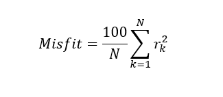
where ???????? are the differences between model’s waveform power and data’s waveform power, normalized for the waveform power’s maximum value and ???? is the number of sampled considered during retracking.
The L2 data products generated in output are in standard NetCDF format (RADS-convention) The file naming convention for the files is: PSG_FBR_INPUT_FILENAME.nc where FBR_INPUT_FILENAME is the filename of the SAR FBR data file given in input. The NetCDF format is self-explanatory with all of the data field’s meaning described in the attributes.
Acronyms
EOP-SER Earth Observation Programmes: Science, Exploitation, Research
FBR Full Bit Rate
GRS Geodetic Reference System
L1A Level 1A
L1B Level 1B
L1B-S Level 1B-S
L2 Level 2
LRMC Low resolution mode with range cell migration correction
RADS Radar Altimeter Database System
RDSAR Reduced SAR SAR Synthetic Aperture Radar
SINC Signal model involving numerical convolutions
SINC2 SINC based conventional altimetry retracker
SINCS SINC based SAR altimetry retracker
SINCS-OV Extension of SINCS introducing orbital wave velocities
WGS World Geodetic System
References
Buchhaupt C., Fenoglio-Marc L., Dinardo S., Scharroo R., Becker M (2018). A fast convolution based waveform modell for conventional and unfocused SAR altimetry, Advanced Space Research Special Issue CryoSat-2, https://doi.org/10.1016/j.asr.2017.11.039
Buchhaupt, C., (2019). Model Improvement for SAR Altimetry, PhD Thesis, University of Darmstadt, tuprints.ulb.tu-darmstadt.de/9015/
Fenoglio L. and Buchhaupt C. (2020). TUDaBo SAR-RDSAR for G-POD Altimetry Coastal and Open Ocean Performance -Algorithm Theoretical Basis Document (ATBD), ESA Reference number: EOEP-SEOM-EOPSTN-17-046, Version 1.6, 30-01-2020
To request access to this processor:
- Register for free on the ESA Altimetry Virtual Lab if not done already.
- Complete the P-PRO (for systematic processing) or P-PRO ON DEMAND (for on-demand processing) service request form on the EarthConsole® Webapp. Please make sure to indicate in the service request form whether you wish to request an ESA Network of Resources sponsorship for your project.
- If choosing the ESA NoR sponsorship, we’ll assess the request and provide the sponsorship request form for your review and approval to be sent to ESA NoR.
- If not opting for an ESA NoR sponsorship, we’ll send a service quotation with payment instructions for your approval.
For further info, please check this pricing list which cover most of the typical users’ requests.
For any question, bug-reports or support on the processor please contact altimetry.info@esa.int and support@earthconsole.eu.