USER MANUAL
Fully Focused-SAR for CS-2 and S-3
Owner: Aresys s.r.l.
The FF-SAR (Fully Focused SAR) for CryoSat-2 and Sentinel-3 is a web service that provides the capability to process on line and on demand CryoSat-2 and Sentinel-3 SAR data, from FBR data products to Level1b FF-SAR products.
The service is based on the AREALT-FF1 Processor Prototype that has been developed by Aresys (http://www.aresys.it) in the framework of ESA contracts for Sentinel-6 and CryoSat-2. The AREALT-FF1 Processor produces L1b FF-SAR altimetry waveforms exploiting the focusing technique in the 2D transformed frequency domain proposed in 1.
The AREALT-FF1 Processor will make use of the P-PRO (Parallel Processing) distributed computing platform to deliver timely the output Level1b products. These output data products are generated in standard NetCDF format.
The output Level1b product includes the variable uncorrected_retracked_height, that contains the surface height computed by the threshold retracker described in 2. It is worth underlining that the threshold is set to 60% and that the geophysical corrections are not applied, but included in variables geophysical_correction_ocean, geophysical_correction_land and geophysical_correction_seaice.
User can also decide whether to fit the waveform using the ALES+ FF-SAR empirical retracking algorithm to estimate range. ALES+ FF-SAR is an adaptation of the ALES+ SAR algorithm described in 3.
The processor prototype is versatile in the sense that the users can customize and adapt the processing, according their specific requirements, setting a list of configurable options.
| Processing Parameter | Values | Description |
| Range oversampling factor |
|
User can decide whether to apply zero padding prior to range compression: 1 if the zero padding has not to be applied, 2 if a zero padding by a factor of 2 has to be applied. It is worth recalling that the instrument samples the waveforms with a 320 MHz clock, providing a nominal_sampling = c / 320e6 / 2 = ~0.468m (with c = speed of light). Applying an oversampling factor waveform_sampling = nominal_sampling / range_oversampling_factor. Note that the altimeter range resolution is fixed and given by the chirp bandwidth of 320 MHz: c / 320e6 / 2 = ~0.468m. |
| Processed bandwidth factor |
|
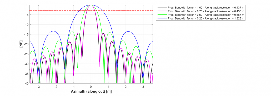
User can decide the fraction of the Doppler bandwidth that is processed to generate the FF-SAR single look waveforms, allowing to control the along-track resolution. Under some approximation the theoretical along-track resolution at -3dB is at_resolution = 1.073*velocity/processed_bandwidth (with velocity the satellite velocity and processed_bandwidth equal to the processed bandwidth factor multiplied by the instrument Pulse Repetition Frequency). |
| Multilook posting rate |
|
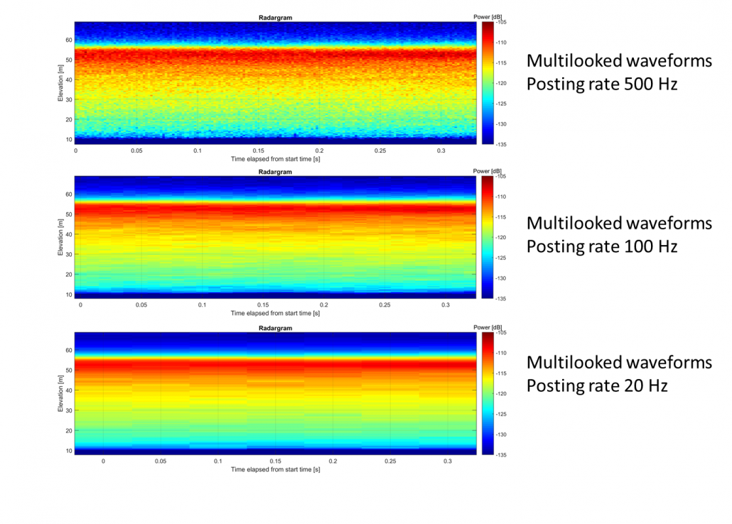
User can decide the posting rate of the FF-SAR multi look waveforms. The processing parameter represents the approximate waveform spacing in frequency (Hz). The actual spacing will vary slightly along the orbit depending on orbital parameters. |
| Append the ALES+ FF-SAR output to the output NetCDF product |
|
User can decide whether to fit the waveform using the ALES+ FF-SAR empirical retracking algorithm to estimate range. Note that this processing parameter, as the algorithm oversamples the multilook waveform by a factor 2, can be selected only if the Processing Parameter “Range oversampling factor” is set to 1. ALES+ FF-SAR is an adaptation of the ALES+ SAR algorithm, see section 2.1.2 of 3. |
It is worth recalling here that along-track resolution is different from along-track sampling rate (i.e. posting rate). The along-track resolution is to be intended as the width at -3dB with respect to the peak power of the along-track point target response. The user can select the along-track resolution by tuning the processed bandwidth factor. In the following figure, the FF-SAR along-track point target response of CryoSat is shown for different values of the processed bandwidth factor, so that the effect on the along-track resolution can be noticed.

The multilook posting rate determines how many waveforms per unit of time are in the output product so that, as the multilook posting rate increases, less single look waveforms at instrument Pulse Repetition Frequency rate are averaged together. The user can select how many single look waveforms are averaged together by tuning the multilook posting rate. In the following figure, it is shown the radargram for a same CryoSat acquisition after FF-SAR processing at different multilook posting rate. It can be noticed that at higher posting rates, the number of waveforms is larger but the speckle noise is more visible.

Processing constraints
The AREALT-FF1 Processor has to be executed providing as input an acquisition segment longer than 2 seconds, that corresponds to the along-track antenna aperture of the CryoSat instrument. This constraint is due to the fact that the AREALT-FF1 Processor exploits the focusing technique in the 2D transformed frequency domain, which operates in a block-by-block basis where the lower limit for a block length is the along-track antenna aperture.
Additionally, the maximum number of products allowed in one single task is 250. This constraint is set in order to limit the duration of a task to less than 72 hours. Tasks longer than this are automatically terminated.
The FF-SAR Level1b data products generated in output are in standard NetCDF format. The NetCDF format is self-explanatory with all the data field significance described in the attributes.
The file naming convention for the output files is :
L1B_FF_ML_starttime_stoptime.nc
where:
starttime is the time of the first sample in the Leve1b product in the format YYYYMMDDThhmmss
stoptime is the time of the last sample in the Level1b products in the format YYYYMMDDThhmmss
In the Level1b product, the following conventions are adopted
The Reference Time for the TAI Datation is 01/01/2000 00:00:00
The Vertical Datum for altitude reference is the WGS84 Ellipsoid
The Level1b product includes the variable uncorrected_retracked_height, that contains the surface height computed by threshold retracker in 2. It is worth underlining that the threshold is set to 60% and that the geophysical corrections are not applied, but included in variables geophysical_correction_ocean, geophysical_correction_land and geophysical_correction_seaice.
Acronyms
FBR: Full Bit Rate
FF-SAR: Fully Focused SAR
SAR: Synthetic Aperture Radar
WGS: World Geodetic System
References
1 Guccione, P., Scagliola, M., Giudici, D. 2D Frequency Domain Fully Focused SAR Processing for High PRF Radar Altimeters. Remote Sens. 2018,
10, 1943. https://doi.org/10.3390/rs10121943
2 Davis C. H., A robust threshold retracking algorithm for measuring ice-sheet surface elevation change from satellite radar altimeters, in IEEE Transactions on Geoscience and Remote Sensing, vol. 35, no. 4, pp. 974-979, July 1997, https://doi.org/10.1109/36.602540.
3 Passaro, M., et al., Absolute Baltic Sea Level Trends in the Satellite Altimetry Era: A Revisit. Frontiers in Marine Science 2021. https://doi.org/10.3389/fmars.2021.647607
To request access to this processor:
- Register for free on the ESA Altimetry Virtual Lab if not done already.
- Complete the P-PRO (for systematic processing) or P-PRO ON DEMAND (for on-demand processing) service request form on the EarthConsole® Webapp. Please make sure to indicate in the service request form whether you wish to request an ESA Network of Resources sponsorship for your project.
- If choosing the ESA NoR sponsorship, we’ll assess the request and provide the NoR form for your review and approval.
- If not opting for an ESA NoR sponsorship, we’ll send a service quotation with payment instructions for your approval.
For further info, please check this pricing list which cover most of the typical users’ requests.
For any question, bug-reports or support on the processor please contact altimetry.info@esa.int and support@earthconsole.eu.


