USER MANUAL
SARvatore for Sentinel-3
Owner: European Space Agency
SARvatore (SAR Versatile Altimetric TOolkit for Research and Exploitation) for Sentinel-3 is a Prototype Software Processor developed by ESA/ESRIN (REF1) to experiment with Sentinel-3 SAR Altimetry processing exploiting the SAMOSA retracking model and the Delay-Doppler principle. It provides the capability to process on line and on demand Sentinel-3 SRAL L1A data products in SAR mode to Level-2 geophysical data products. It can be used over open ocean or coastal zone, as well as over more difficult targets such as rivers, lakes, and sea-ice.
The service is based on the Sentinel-3 SARvatore Processor Prototype, heritage of the CryoSat-2 SARvatore Processor Prototype.
The data products in input to the service are the Sentinel-3 SRAL L1A data products.
The Sentinel-3 SARvatore Processor has two stages: L1b (SAR) & L2 (retracking).
The processor makes use of the P-PRO distributed computing platform to deliver timely the output data products.
These output data products are generated in standard NetCDF format (using CF Convention) and are compatible with BRAT (Basic Radar Altimetry Toolbox) and other NetCDF tools.
The processor prototype is versatile in the sense that the users can customize and adapt the processing, according to their specific requirements, by setting a list of configurable options.
The configurable options are divided according to the processing level they refer to (L1b and L2). Here, you find them listed with a basic description of their significance.
L1b Processing Options:
| Option Name | Option Value | Option Description |
| [Pre-Processing]
Pass Direction |
|
Flag to select whether to process all or only ascending/descending passes. |
| Data Posting Rate 20Hz/80Hz |
|
Users can decide here the posting rate (20 Hz or 80 Hz) of the L2 data published in output.
20 Hz corresponds to a distance between samples of about 320 m and 80 Hz to about 80 m. |
| Range Walk Correction |
|
Flag to set the application of the Range Walk on the burst data (remember to set exact-beam steering when Range Walk is activated). |
| Hamming weighting Window |
|
Users can decide here whether to apply or not a Hamming weighting window on the SAR burst dataor to apply it only for surface locations in coastal area (more info in REF2). |
| Beam-Forming |
|
Users can decide here whether to operate an exact Beam-Forming or an approximated Beam-Forming (more info in REF2). |
| FFT Zero-Padding |
|
Users can decide here whether to operate the Zero-Padding prior to the range FFT (section 4.8 in REF2). Zero-Padding is indicated for coastal zone and sea-ice analysis. |
| Radar Receiving Window Size |
|
Users can select here the size of the radar receiving window: 128 range bins (standard) or 128XN range bins (extended N times). Extended window with N=2 is indicated for coastal zone and sea ice analysis. N>2 may be indicated only for inland water over very steep topographic regions. |
| Stack Subset |
|
Subset the Stack to Looks: [100, 120, 140, 160, 180, ALL]. |
| Antenna Pattern Compensation |
|
Users can decide here whether to apply the Antenna Pattern Compensation on Stack Data prior to perform the multi-looking. |
| Dump SAR Stack Data in output |
|
Users can choose here to post in output SAR Stack Data Products for each selected pass. Users can select whether to dump just the power of the Stack data or the power and phase.
Beware: SAR Stack Data Products are quite bulky (usually 2 GB for 10 minutes of data); we recommend to process SAR Stack Data singularly or max 5 passes at a time: contact the P-PRO team for a massive production of SAR Stack Data. |
L2 Processing Options:
| Option Name | Option Value | Option Description |
| Restrict the re-tracking on specific surfaces |
|
Users can decide here whether to process the whole pass, only points in open sea or only water points (i.e., points in open sea, coastal zone and inland water). |
| PTR width alphap parameter |
|
Users can decide here whether to use a LUT (Look-Up Table) or a constant for the PTR (Point Target Response) alphap parameter. |
| SAMOSA Model Generation |
|
Users can decide here which SAMOSA retracking model to use in the processing (SAMOSA2, SAMOSA3, SAMOSA+).
The SAMOSA 3 is a truncated version of SAMOSA 2 (only zero-order term); more info in REF3. SAMOSA+ is an enhancement of the SAMOSA2 solution providing better performances over inland water, coastal zones and sea ice; more info in REF4. |
| Dump RIP in output |
|
Flag to append the Range Integrated Power (RIP) in the output NetCDF data product. |
| Dump SAR Echo Waveforms in Output |
|
Users can choose here to append the SAR Echo Waveforms in the output product. |
| Single-Look or Multi-Look Model |
|
Users can decide here to retrack the waveform with the Multi-look waveform model or the single-look waveform model. Single-look waveform model is an acceptable approximation over inland water or sea-ice scenario. The Single-Look option is quicker than Multi-Look option. |
| Choose the Default Tide Model |
|
Users can decide here which tide model to use as default in the product between FES2014b, TPXO8-ATLAS, TPXO9-ATLAS. |
| Choose the Default Mean Sea Surface Model |
|
Users can decide here which mean sea surface model to use as default in the product between DTU18, DYU15, CLS-CNES15. |
| [Post-processing]
Append the ALES+ SAR output to the output NetCDF product |
|
Flag to append the ALES+ SAR retracker estimates to the output NetCDF product. |
Adopted Conventions
- The Reference Time for the TAI Datation is 01/01/2000 00:00:00
- The Vertical Datum for altitude reference is the WGS84 Ellipsoid
- The Curve Best-Fitting Scheme, used in the re-tracking stage, is a Bounded Levenberg-Marquardt Least-Squares Estimation Algorithm (LEVMAR-LSE).
- The SAR Power Return Waveform Model, used in the re-tracking stage, is the SAMOSA Model (REF3).
- Static bias has been applied to the range, sigma nought and antenna mispointing measurements. The values of the static biases are reported in the output NetCDF data products.
- The product orbit latency/source is the one coming from the SAR L1A data file used in input.
- The orbital altitude has been corrected for a Time Tag Bias. The value of the applied time tag bias is reported in the output NetCDF data products.
- The measurements are posted both at rate of 20 Hz/80 Hz and of 1 Hz.
- The sea state bias correction has not been applied to the sea level anomaly estimates.
- No a priori data editing has been applied to the 20 Hz/80 Hz measurements.
- The misfit between SAR Waveform Model and SAR Waveform Data has been computed as:
sqrt( 1/128*sum(residual)^2 )*100
where residuals are the differences between model’s waveform power and data’s waveform power, normalized for the waveform power’s maximum value.
Known Limitations of Sentinel-3 EarthConsole® P-PRO Products
The Sentinel-3 products feature the following limitations:
- The Dual Frequency Ionosphere Correction (Ku&C) is not computed. Instead, the ionosphere correction from the JPL GIM model is provided in the L2 product.
- The MWR wet tropospheric correction is not computed. Instead, the wet tropospheric correction from the ECMWF model is provided in the L2 product.
- The sea state bias solution in the L2 product is the CLS 2012 Jason-2 SSB solution.
The L2 data products generated in output are in standard NetCDF format (CF-convention), fully compatible with BRAT.
The file naming convention for those files is :
RES_INPUT_FILENAME.nc
where:
INPUT_FILENAME is the filename of the SAR L1A data file given in input
(for more details on the input filename, please check the product specification)
The NetCDF format is self-explanatory with all the data field significance described in the attributes.
Along with the NetCDF file, it is provided in output a .png picture of the radar data image (Radar Echogram) and a .kmz file of the satellite pass ground-track.
By selecting the corresponding option, users can decide to post in output also the SAR Stack Data Products, still in NetCDF format.
The naming convention for those stack data products is :
STK_INPUT_FILENAME.nc
They will be held in the STACK folder inside the .tgz output package.
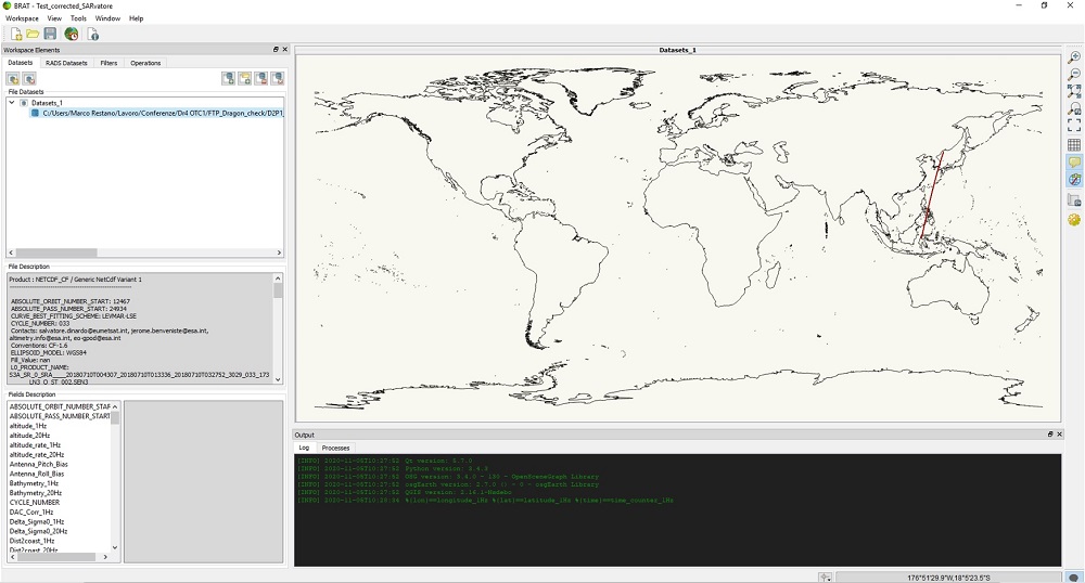
SARvatore products can also be opened in the Broadview Radar Altimetry Toolbox (BRAT). However, when products are loaded, the track is not correctly displayed on the BRAT map and an error is reported:
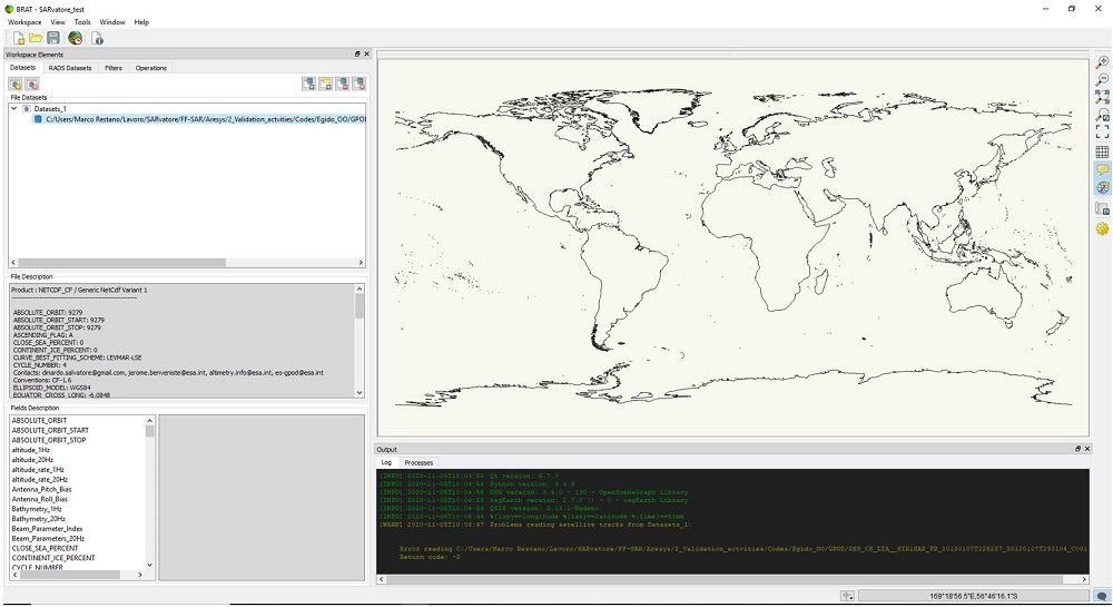
The toolbox is able to read:
- all altimetry data from official data centres (from ERS-1 and 2, Topex/Poseidon, Geosat Follow-on, Jason-1, Envisat, Jason-2, Cryosat and Sentinel-3, from Sensor Geophysical Data Record to gridded merged data);
- any NetCDF file.
In the latter case, a small edit is needed to correctly visualize the track associated with the input products.
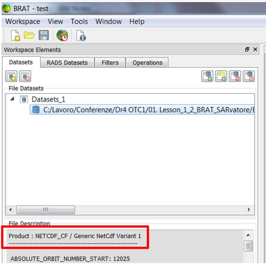
Considering SARvatore products, the NetCDF file is associated with the NETCDF_CF / Generic NetCdf Variant 1 format:
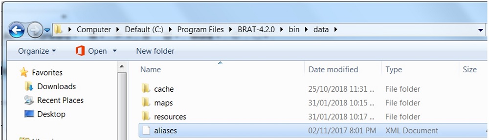
Therefore, to correctly display the track on the BRAT map, users shall close the program, open the bratXX/bin/data folder:
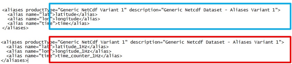
and edit the aliases.xml file as follows in the Generic NetCdf Variant 1 section:
- change the latitude to latitude_1Hz ;
- change the longitude to longitude_1Hz;
- change the time to time_counter_1Hz (or those at 20Hz).
Once the track is loaded again in BRAT, it will be correctly displayed and no error will be reported:
More information can be found in Chapter 5 of the BRAT user manual available here.
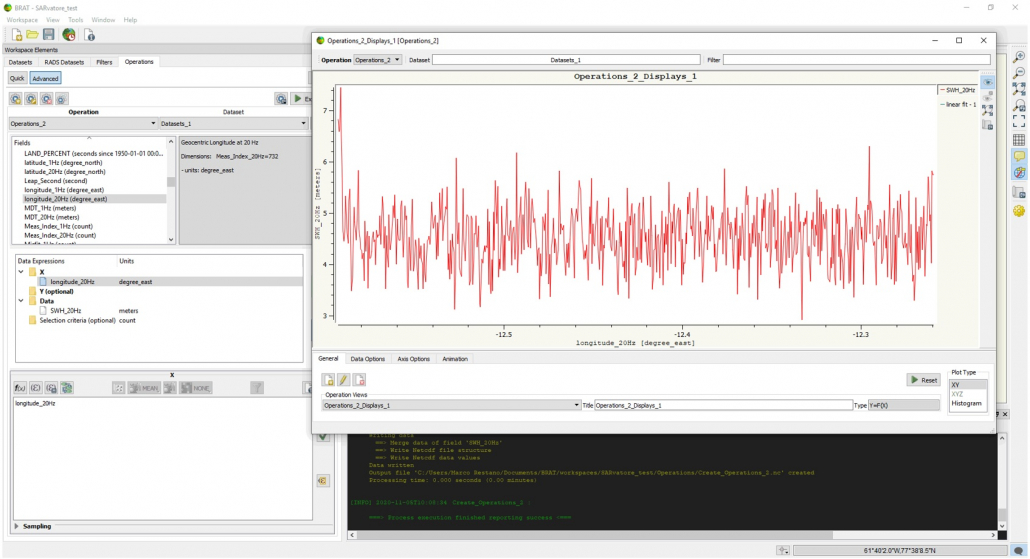
Afterwards, SARvatore products can be processed in BRAT using the Advanced option in the Operations menu.
To learn how to use BRAT, please consider the material available at the following links:
- https://youtu.be/PdnSalcOUHA
- https://www.youtube.com/watch?v=PdnSalcOUHA
- or, equivalently, the material associated with the lesson: “SARvatore & BRAT Demos“.
Acronyms
SAR: Synthetic Aperture Radar
WGS: World Geodetic System
EOP-SER: Earth Observation Programmes: Science, Exploitation, Research
CF: Climate & Forecast
LUT: Look-Up Table
L1A: Level 1A
L1b: Level 1b
References
REF1: Dinardo S. and Benveniste J. (2013): Guidelines for the SAR (Delay-Doppler) L1b Processing; European Space Agency/ESRIN Report, issue 2.3, XCRY-GSEG-EOPS-TN-14-0042, available at: https://wiki.services.eoportal.org/tiki-download_wiki_attachment.php?attId=2540
REF2: Guidelines for the SAR (Delay-Doppler) L1b Processing, ESA, 2013, available here
REF3: (SAMOSA Model Paper) Ray, Chris & Martin-Puig, Cristina & Clarizia, M.P. & Ruffini, Giulio & Dinardo, Salvatore & Gommenginger, Christine & Benveniste, Jerome. (2015). SAR Altimeter Backscattered Waveform Model. Geoscience and Remote Sensing, IEEE Transactions on. 53. 911-919. 10.1109/TGRS.2014.2330423.
REF4: Dinardo, Salvatore & Fenoglio, Luciana & Buchhaupt, Christopher & Becker, Matthias & Scharroo, Remko & Joana Fernandes, M & Benveniste, Jérôme. (2017). Coastal SAR and PLRM altimetry in German Bight and West Baltic Sea. Advances in Space Research. 62. 10.1016/j.asr.2017.12.018.
To request access to this processor:
- Register for free on the ESA Altimetry Virtual Lab if not done already.
- Complete the P-PRO (for systematic processing) or P-PRO ON DEMAND (for on-demand processing) service request form on the EarthConsole® Webapp. Please make sure to indicate in the service request form whether you wish to request an ESA Network of Resources sponsorship for your project.
- If choosing the ESA NoR sponsorship, we’ll assess the request and provide the sponsorship request form for your review and approval to be sent to ESA NoR.
- If not opting for an ESA NoR sponsorship, we’ll send a service quotation with payment instructions for your approval.
For further info, please check this pricing list which cover most of the typical users’ requests.
For any question, bug-reports or support on the processor please contact altimetry.info@esa.int and support@earthconsole.eu.